
Actualité volcanique, Articles de fond sur étude de volcan, tectonique, récits et photos de voyage
Par Bernard Duyck
May 1960 ... a sad anniversary , and a chain of fatal events: the largest earthquake, ever recorded , followed by tsunamis, and a few days after , a volcanic eruption that hit Chile.
Involved the plate tectonics ... the decor is drawn , it remains to analyze the sequence of events .
Earthquakes of May 1960 :
After shaking on May 21 , an earthquake measuring M 9.5 on the MMS scale, called Valdivia earthquake, or Great Chilean earthquake, has struck Chile on May 22, 1960 at 3:11 p.m. local ( 7:11 p.m. GMT). The epicenter is located near Lunaco , 570 km south of Santiago. Valdivia was the most affected city.
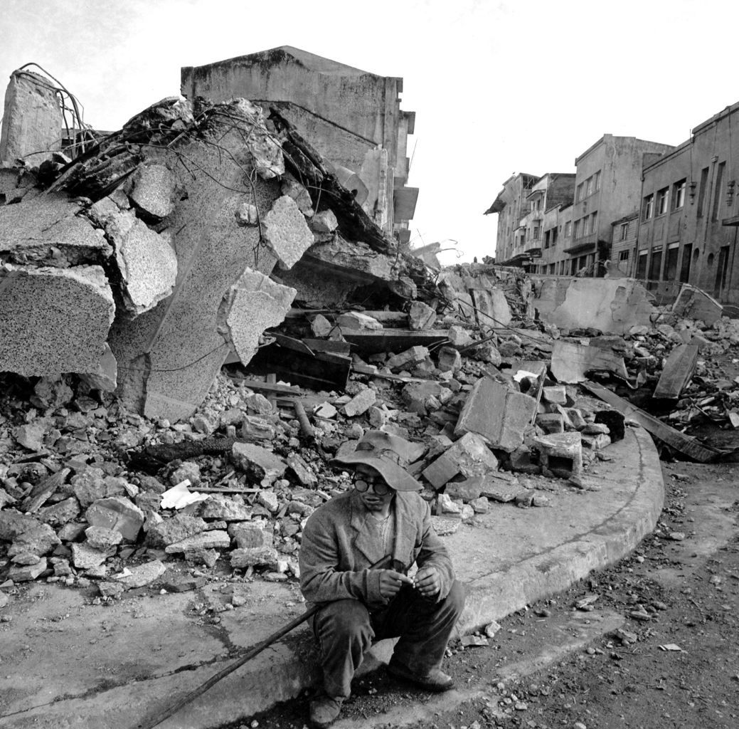
Valdivia earthquake in May 1960 - Doc. Press Association

Valdivia earthquake of 05/22/1960 - M9, 5 - Scale of felt - doc . USGS
The earthquake generated local tsunamis. A wave of 8 m high hit the Chilean coast , mainly between Concepción and Chiloé Island , at 16:20 UTC. Ten minutes later , another wave 10 meters high has occurred. Many coastal villages were affected, such as Tolten , which disappeared. Thousands of people were killed, the range of between 2,230 and 5,700 deaths estimated . Material losses were estimated at 400-800 million dollars ( 2.9 to 5.8 billion, after adjusting for inflation)
The main tsunami that resulted traveled the Pacific and hit Japan , the Aleutian Islands , the Philippines , eastern New Zealand, southeast Australia and devastated Hilo / Island of Hawaii 15 hours after the earthquake. Waves over 10 meters were recorded to 10,000 kilometers from the epicenter.
Soil subsidence destroyed buildings , deepened local rivers , and created wetlands in Rio Cruces and Chorocomayo . All water supply and electricity systems of Valdivia were destroyed. Mudslides engulfed homes, polluted rivers and groundwater.

Travel time of the main earthquake tsunami consecutive Valdivia - doc NOAA
These earthquakes mark the release of mechanical stress between the subducting Nazca plate beneath the South American plate at the Peru -Chile trench . The rupture zone concerns 800 km long, between Arauco , 37 ° S, and Chiloé Archipelago , 43 ° S. The rupture velocity is estimated at 3.5 km. per second .

Cordon Caulle - 05/24/1960 eruption - photo www.lmneuquen.com.ar
The eruption of the Cordon Caulle - May 24.
Thirty-eight hours after the earthquake in Valdivia, a vent located in the rift zone of the Cordon Caulle , near the Puyehue , 240 km . east of the rupture zone , erupts. It is accompanied by the emission of a subplinian plume in fungus above, and fumes émisssions along the crack . The most active centers were initially the Gris crater , followed by Azufral crater . The impact of white pumice recorded at 30-40 km. vent has a thickness of more than 10 cm .

Cordon Caulle - 05/24/1960 eruption - photo Geophisical NOAA data center
The next phase, of rhyodacite ( 68.9-70.01 % SiO2 ) fissural eruptive type,was little observed , poorly documented by local media , too busy with the consequences of earthquakes. It has fueled a crack 5 5 km long , where 21 vents were identified. It produces lava block and a'a flows.
A third phase , characterized by the emission of rhyodacitic lava is supplied through vents oriented NNW transversely to the main crack ; it ends with an emission of viscous lava obstructing the vents ... explosions continue tp the Gris and Azufral craters, to decline on July 22 .
Between May 24 and July 30 ( end date of the eruption given by GVP ) , a volume equal to 0.25 km ³ DRE ejecta and lava flows were issued. The volcanic explosivity index was set to 3, of the same order as that of the 2011-2012 eruption much more documented.

The flows of the 1960 eruption are pink colors ( Ph.1 pumice ) er red ( Ph.2 lava ) - Doc. Singer et al.
The dynamic stress at the subduction zone and its extension towards the continent may have favored conditions for the reactivation of the system , all facilitated by the presence of silicic magma near the surface.
Sources :
- Rhyodacitic fissure eruption in Southern Andes (Cordon Caulle; 40.58S) after the 1960 (Mw:9.5) Chilean earthquake: a structural interpretation – by L.E. Lara, J.A.Naranjo, H. Moreno.
- Doc archives NOAA.
- Global Volcanism Program - Puyehue - Cordon Caulle
Thème Magazine - Hébergé par Overblog


/image%2F0935525%2F20221018%2Fob_28398d_traces-ds-depot-de-surge-er-avell.jpg)
/image%2F0935525%2F20220314%2Fob_7fda0c_2022-03-13-06h43-reventador-webca.jpg)
/image%2F0935525%2F20201213%2Fob_d5dcbe_2020-12-10-arbre-petrifie-stonisi.jpg)
/image%2F0935525%2F20201122%2Fob_5dc433_nov-21-2020-2-parco-archeologic.jpeg)