
Actualité volcanique, Articles de fond sur étude de volcan, tectonique, récits et photos de voyage
Back in the archipelago of Cape Verde with recent photos of Carole and Frederic Hardy, who made a trek on the island of Fogo south of the archipelago, and to the north, on the islands of Sao
Vicente and Santo Antao .
A video by way of introduction :
The Cape
Verde Islands are the top of the Cape Verde bulge, an area of about 1,000 km in diameter amounting to several thousands of meters above the seafloor .
This bulge is associated with the Cape Verde mantle plume and near the point of
rotation of the African plate. Seismic tomography revealed an
abnormality like a mantle plume under the bulge reaching 1900 km depth (Montelli & al. 2004).
The islands are organized in an horseshoe opened to the west. They show an increase of age from east to west, both on the north island
chain than on the south chain.
Volcanic activity began in the early Miocene to 24-22 Ma. The magmatism involves mixtures undersaturated in silica, alkaline composition from basanite to tephrite , and presence of phonolites and
carbonatites on some islands.
 The Cape Verde archipelago - doc.
photo Envisat /annotated by B.Duyck
The Cape Verde archipelago - doc.
photo Envisat /annotated by B.Duyck
 Cape Verde Archipelago and indication of the age of shield volcanoes for each island
Ages compiled from Mitchell et al.
( 1983), Gerlach et al. (1988 ) TORRES (1998); JORGENSEN & HOLM
(2002); TORRES et al. (2002) PLESNER et al. (2002 ) MADEIRA et al. (2005); HOLM et al. (2006 , 2008); Duprat et al. (2007 )
.
Fogo Island is the only in
the archipelago with an active volcanism during historical times . Fogo Island shares a
common volcanic apron with the island of Brava in the south -west.
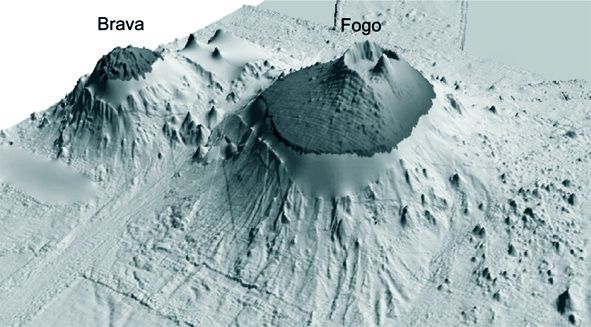 3D
model of the platform Brava- Fogo - Fogo to the east, and traces of the debris avalanche of Monte Amarelo - between the two islands , a group of underwater volcanic cones - Modified after
Masson et al.
3D
model of the platform Brava- Fogo - Fogo to the east, and traces of the debris avalanche of Monte Amarelo - between the two islands , a group of underwater volcanic cones - Modified after
Masson et al.
(2008 )
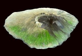
 The island of Fogo and
his eccentric caldera, housing the stratovolcano Pico do Fogo - Nasa satellite picture EO-1 ALI 2009
The island of Fogo and
his eccentric caldera, housing the stratovolcano Pico do Fogo - Nasa satellite picture EO-1 ALI 2009
 Fogo
- Cha das Caldera, occupied by lava flows and the Pico do Fogo, is inhabited as evidenced by the villages and the road visible from the satellite - NASA satellite view EO- 1 ALI 2009
Fogo
- Cha das Caldera, occupied by lava flows and the Pico do Fogo, is inhabited as evidenced by the villages and the road visible from the satellite - NASA satellite view EO- 1 ALI 2009
 Fogo - the stratovolcano Pico do Fogo - photo © Carole and Frederic Hardy 2013.
With a diameter of 25 km, the island culminates at Pico do
Fogo stratovolcano 2829 m.
above sea level ( 6,000 meters above the sea floor ) : This " volcano within a volcano " is included in a caldera , 9 km wide , which remains only the Western wall, The Bordeira, high of over 1,000 meters. This caldera is divided into two major entities , the Cha das Caldeiras plain and the young stratovolcano Pico do Fogo . Bordered to the north and
south by scars of collapse, the caldera opens widely to the east following two huge landslides, accumulating 150 to 200 cubic kilometers .
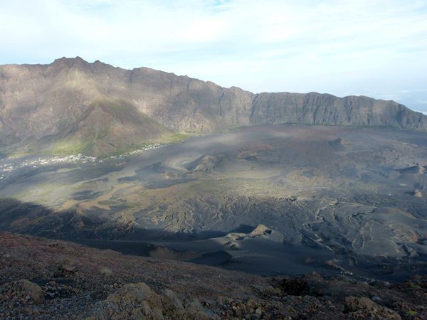 Fogo
- part of The Bordeira , with the villages of Portela and Bangaeira in the Cha das Caldeiras plain, seen from Pico do Fogo - Photo © Carole and Frederic Hardy 2013.
Fogo
- part of The Bordeira , with the villages of Portela and Bangaeira in the Cha das Caldeiras plain, seen from Pico do Fogo - Photo © Carole and Frederic Hardy 2013.
 To the right ASTER image of Fogo - left, a model of Piton de la Fournaise / Reunion .
This configuration can be found on
other islands hot spot , especially at Piton de la Fournaise, Reunion .
The geological history of Fogo can be divided into four
main phases:
1 . The underwater volcano composed of
carbonatites and alkaline basalts is dated ~ 4.5 Ma
2 . The group of older lavas , Monte Barro Group , encompassing
carbonatites lack of precise dating .
3 . Monte Amarelo Group, Quaternary aged, consists of 2 to 3 km
thick highly alkaline lavas and cinder cones . Its activity ends with the giant lateral
collapse, more than 10,000 years ago .
The Monte Amarelo volcano is suspected of possessing a durable magma chamber in the crust, which disappeared after this gigantic collapse , and would not have time (geologically ) to
reform since .
 Fogo
- contours of Cha das Caldeiras, Pico do Fogo, and deposits of debris avalanche / Monte Amarelo group - map MASSON & al. (2008).
Fogo
- contours of Cha das Caldeiras, Pico do Fogo, and deposits of debris avalanche / Monte Amarelo group - map MASSON & al. (2008).
4 . Cha das Caldeiras group is older than 62,000
years to the present, it is characterized by alkaline volcanic rocks forming a layer of 2 km. thick that fills the scar ofcollapse , and the Pico do Fogo .
Pico do Fogo was monitored visually since the 1500s .
From 1500 to 1769 , its eruptive activity is concentrated at the top of the stratovolcano, punctuated by periods of frequent and prolonged eruptions interspersed with calm over several decades
. The last summit eruption is dated 1785.

During the 18th century , the seat of activity moves to the sides , at a crack oriented NS , this change is interpreted as a structural reconfiguration of the volcanic system , linked to a
renewed instability of the eastern flank (Day & al. 1999)
The
two most recent eruptions , dated respectively 1951 and 1995 are well documented and have led to a recent study of dynamics animants the plumbing system of Fogo .
To be continued ...
Sources:
- Global Volcanism Program - Fogo
- Magma storage and ascent of historic and prehistoric eruptions of Fogo
Cape Verde Islands: A barometric , Petrologic and geochemical approach - by
Elliot Hildner / University of Bremen
- The role of mass movements on the
geomorphologic evolution of island volcanoes : examples from Fogo and Brava in the Cape Verde archipelago - by J. Madeira et al.
Thème Magazine - Hébergé par Overblog


/image%2F0935525%2F20221112%2Fob_03b696_ethiopie-scanner-bd-018.jpg)
/image%2F0935525%2F20221111%2Fob_1285d5_site-troglodyte-de-jonas-jmm.jpg)
/image%2F0935525%2F20221108%2Fob_d0f7fc_site-troglodyte-de-jonas-jmm.jpg)
/image%2F0935525%2F20221110%2Fob_af1829_puy-mary-2-jmm-1-28-10-2022.jpg)