
Actualité volcanique, Articles de fond sur étude de volcan, tectonique, récits et photos de voyage
Par Bernard Duyck

Flores / Azores - Baia Alagoa Cedros - photo Angrense
The island of Flores, 10 km. 5, was formed during the Pleistocene, with the growth of a submarine volcano, and explosive activity associated with the formation of small calderas and many cones and craters.
After a long rest period of 200,000 years, young craters of phreatomagmatic eruptions and lava flows were produced during the Holocene.

Flores / Azores - Rocha dos Bordes - photo siaram casacacorianas

Flores / Azores - Rocha dos Bordes, under evening light - photo Visitazores
One of the most famous natural monuments Azores, the Rocha dos Bordões, is a set of vertical basaltic organs. This disjunction prismatic, in relation to a mugearite flow, dated 570,000 years, suddenly appeared on top of an elevation. Partially covered with mosses, lichens and other vegetation, the basalt stone changes colors during the day ... to see these changes, the Rocha dos Bordões requires repeated visits at different times of day.

Flores / Azores - The Lagoa Funda & Rasa - photo Helena Rodrigues / Açores.net
Calderas Rasa and Funda de Lajes were formed there 3150 years.These depressions are two explosions craters associated with hydromagmatic eruptions based in the mountains of southern sector of Flores. They are occupied by lakes and located at different altitudes. The eruption of the caldera Funda, a tuff ring, was accompanied by lava flow towards the southeast, reaching the coast at Lajes.

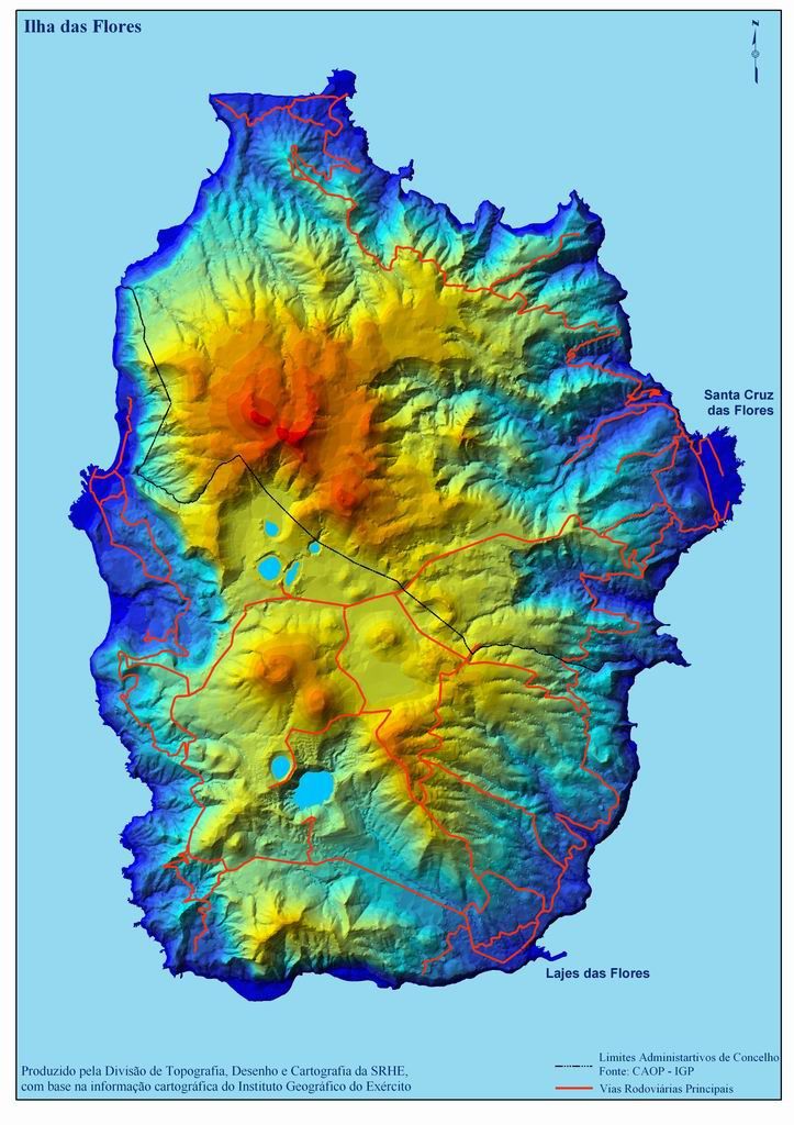
Flores maps - in the center, the caldera Branca, Seca, Comprida and Negra - south, the calderas Funda & Rasa - a click to enlarge.
More central to the "Island of Flowers", there are four calderas, deriving from explosions of maars, in connection with hydromagmatic eruptions on the central plateau: the calderas Branca, Seca, Comprida and Negra.
Except caldera Seca, they are occupied by lakes. The caldera Negra is 108 meters deep which makes its waters dark, and earned him his name. Caldera Comprida, a tuff ring in the caldera Seca, is dated of 2,900 years. It produced a lava flow, heading north-west, joined the coast to Faja Grande.
Isolated from others, Caldeira da Lomba is surrounded by a small rise and bouquets of hydrangeas.
Agua Quentes is a collection of hot and sulfur springs.
Flores / Azores - Caldera Seca - photo Geoparque Azores

Flores / Azores - the calderas Negra and Comprida - photo Geoparque Azores

Flores / Azores - Caldera Seca - photo Geoparque Azores
Craters, lakes and rivers mark the island landscape. The river water short quietly on the surface of the central plateau, or cascade in many falls and winds along broad and deep valleys. Before flowing into the ocean, it gives strength to the various hydroelectric turbines on the island.
Area of Faja Grande - Fajãzinha is one of the most beautiful coastal landscapes of the Azores. On the vast green wall that borders this area can be observed almost twenty waterfalls, including that of Ribeira Grande, which rushes a jump of 300 meters. At the base of the slope, there are various permanent water bodies, such as Poço do Bacalhau or Poço da Alagoinha, also known as Duck Lake.

Flores / Azores - Faja Grande - photo Geoparque Azores

Flores / Azores - Faja Grande - photo Geoparque Azores
Countless islands, points, shoals, inlets, coastal caves, disjunctions prismatic, waterfalls and shady valleys are some of the features offered by the coastal strip of Flores. TheFajã Nova, to Ponta da Rocha Alta, and Fajã de Lopo Vaz form the high cliffs of the south coast, accessible by a footpath that runs along the cliff.
The north side of the island, and linear low coastal cliffs between Ponta Delgada and Ponta do Albarnaz gives way to impassable reliefs of the north-east coast, only crisscrossed by hiking trails, such as the one from the lighthouse to Albarnaz to Ponta da Faja, a difficult journey rewarded with spectacular views ..
Conversely, in the lava fajãs Santa Cruz, Lajes and Fajã Grande, sea softly embraces the low rocky peaks of black lava and lets see, in calm weather, the wildlife of the seabed.
Near the promontory of Ponta da Caveira, Gruta dos Enxaréus forms a cavity 50 meters long and 40 m high, including 15 m underwater.

Flores / Azores - landscape of fajãs / lava deltas

Flores / Azores - Gruta dos Enxaréus - photo time to go
The Ilhéu de Monchique, 1.5 km. off, form the ultimate point of Europe to the west, before the expanses of the Atlantic. At the time when navigation depended solely on astronomical data, the island was an important point of reference for the calibration of instruments of marine navigation.

Flores / Azores - the Ilheu do Monchique - photo Dreizung
Thème Magazine - Hébergé par Overblog


/image%2F0935525%2F20220824%2Fob_233d4b_thrihnukagigur-volcano-guide-to-icelan.jpg)
/image%2F0935525%2F20220111%2Fob_894d24_particolare-dei-colli-euganei-il-mon.jpg)
/image%2F0935525%2F20201012%2Fob_4fcdc5_img-8284-copie.jpg)
/image%2F0935525%2F20200802%2Fob_46d8ae_columbretes-seis1-castellonturismo.jpg)