
Actualité volcanique, Articles de fond sur étude de volcan, tectonique, récits et photos de voyage
Par Bernard Duyck
Back to Cap Blanc Nez, lets talk to the chalk layer of the Cenomanian, called the "blue chalk."
It 's in this layer of chalk that the tunnel under the Strait of Dover was drilled to a depth between 40 meters and over 100 meters below the seabed.

Geological profile of the land in which was dug the Channel Tunnel - according Image Channel Tunnel geological profile / Order Keane.
This strait called Strait of Dover or pas de Calais for our French friends, marks the boundary between the North Sea and the English Channel, and separates orunited, depending on your point of view, the continental Europe to Great -Britain.
The chalk cliffs that dresses the coast on both sides of the strait remind us that it is opened and closed several times during its history ... at a time when Britain was reachable on foot.


Above, Network of paleovalleys during the last glaciation, 25,000 to 20,000 years ago - down, the River Channel to the same period - Doc. The Channel River during the Last Glacial Maximum (20 -25à-ka), alleging Toucanne (2007), modified Elhers and Gibbard (2004)
The paleo-river Channel flowed there. Its history is complex and controlled by tectonics and the extension of the Pleistocene glaciers.
Previously, the Western Channel has functioned as a Pliocene gulf, with a mouthpiece / shoreline evolving according to changes in the level of the sea.
The establishment of vast ice sheets, several kilometers thick, in the middle Pliocene gave him his greatest importance ... in this maximum configuration, the Channel river harvested the waters of contemporary rivers : Orne, Seine, Somme, Thames, Rhine, Meuse , Weser Ems, Elbe and the meltwater from the British, Scandinavian and Alpine (via the Rhine) ice caps. The size of its watershed is then estimated at 1.2 million square kilometers.


Glacial Lake Elsterian 450,000 years ago - left, Doc. Gupta et al. - Right, doc. Cohen, Gibbard and Busschers, 2005. - a click for enlarge
During the Pleistocene, a glacial dam prevented the flow of the Thames and the Rhine / Meuse in the North Sea, and formed a glacial lake northeast of the Weald-Artois anticline; south-west of it, a lower paleo-valley linked the current Great Britain to the continent.
Two gigantic outbursts will cut this connection. The first occurs about 425,000 years ago, and the water cascading in force, more than a million cubic meters per second, will dig and expand the Strait of Dover and flood the lowlands, leaving diamond shaped islands, found during explorations with sonar in the Channel today.
The second flood, more important than the first, occurs there are about 225,000 years; it will bisect the remaining thin peninsula.
A study of 2007conclue that the English Channel was created by erosion of the land bridge linking the Weald in the UK and the Boulonnais in France. More resistant portions of chalk left on both sides the white cliffs of Dover and the Cap Blanc Nez.
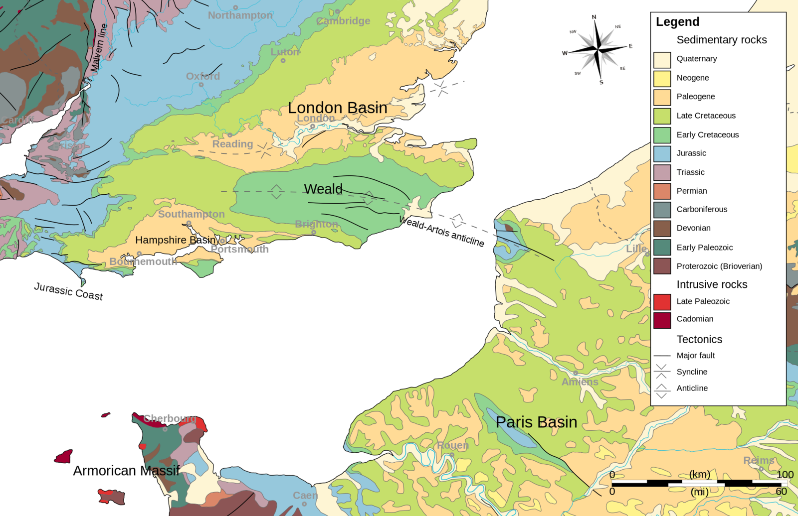
Location of the anticline Weald - Artois - Doc. Wikipedia
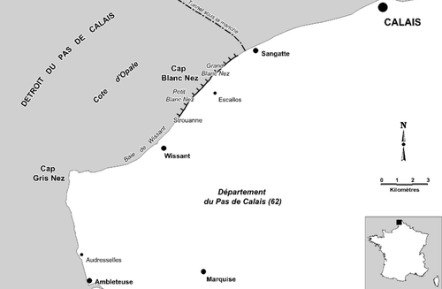

The chalk cliffs of Blanc Nez and of the White cliffs of Dover.- a clic to enlarge
Unless this is a phenomenon of rifting, a sudden collapse between two faults, which is the cause of the invasion of the paleo-valley by waters, the cliffs of Dover and Cap Blanc Nez marking the edges of the fracture.
The River Channel should again see the day when the next ice age ... in "another life"!
The permanent erosion of the cliffs on both sides of the Channel set back ever ... amending the foot of these, and also the route of the roads that dominate.
Two examples:
- The Blanc Nez, where a bunker broke, leaving concrete remnants on the beach,
- Or on the cliffs of Dover, where in 2011, an area the size of a football field has collapsed, leaving a very white scar and a chalk delta bordering the Channel.
This makes these places ...dangerous, but interesting for researchers of fossil ... that are renewed at the foot of debris by this destructive natural action.
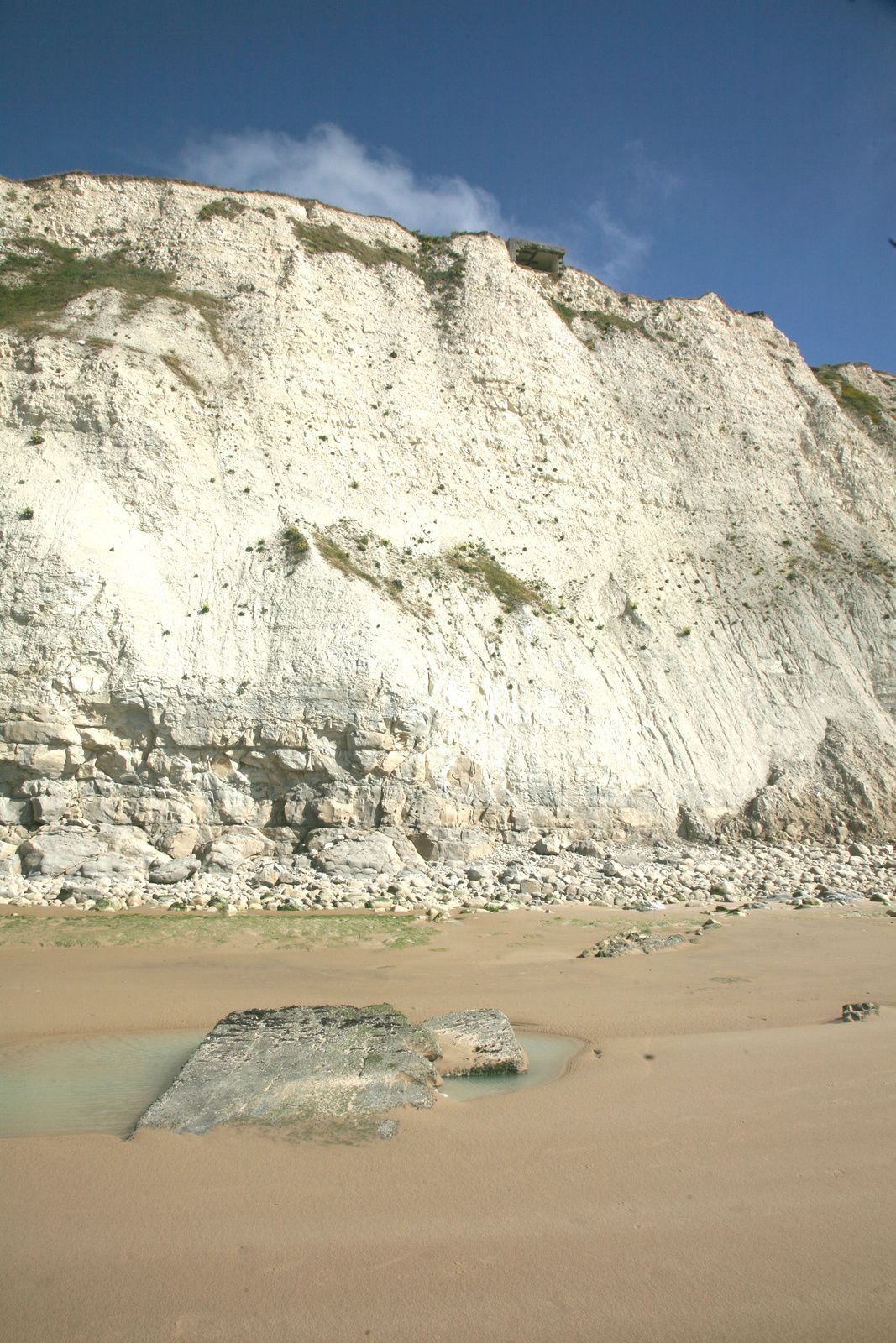
Cap Blanc Nez - ripped blockhouse at the top of the cliff of Petit Blanc Nez and remains on the beach - photo Bernard Duyck 2015

Dover cliffs - the cliff-fall happened between Langdon Cliffs and South Foreland Lighthouse - photo John Mc Lellan / the Daily Mail 2012
Sources :
- Geologie info- Un aperçu de la géologie du Boulonnais – par André Holbecq - link
- Le GR du littoral, de Bray-Dunes à Berck – par Pierre Leflon – link
- Falaises de craie - link
- Falaises de craie - le Cap Blanc Nez - link
- Geology of Dorset: The Cretaceous rocks - link
- Daily Mail - The crumbling cliffs of Dover: Now France is even further away as thousands of tons of chalk crash into sea after frost and drought - link
Thème Magazine - Hébergé par Overblog


/image%2F0935525%2F20220824%2Fob_233d4b_thrihnukagigur-volcano-guide-to-icelan.jpg)
/image%2F0935525%2F20220111%2Fob_894d24_particolare-dei-colli-euganei-il-mon.jpg)
/image%2F0935525%2F20201012%2Fob_4fcdc5_img-8284-copie.jpg)
/image%2F0935525%2F20200802%2Fob_46d8ae_columbretes-seis1-castellonturismo.jpg)