
Actualité volcanique, Articles de fond sur étude de volcan, tectonique, récits et photos de voyage
A subglacial debacle marked the river Skaftá this January 20.
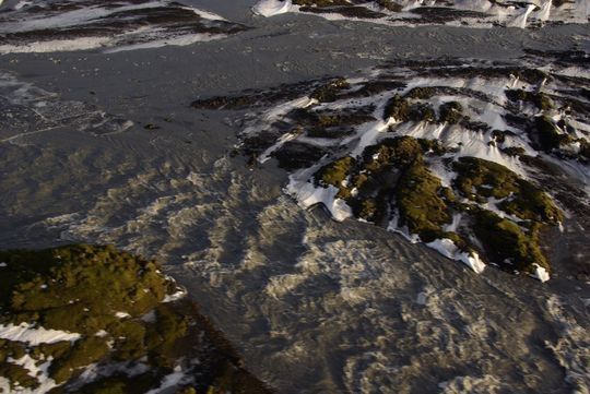 The debacle in Skaftá River, 01/20/2014 - photo Reynir Ragnasson - IMO
"
Jökulhlaup " is the Icelandic term for a sub-glacial meltdown, literally " ice race."
Several types of jökulhlaups therefore exist depending on the feeding mechanism ( fusion of meteorological origin, hydrographic interglacial network modification, subglacial volcanic eruption )
and the position of the tank ( englacial lake, juxtaglaciaire lake or supraglacial lake).
In this case, the melting of the glacier under the heat of the volcano, forms a lake; he can become unstable enough to pour out suddenly through channels at the base of the glacier overcoming the
volcano, and create a major flood .
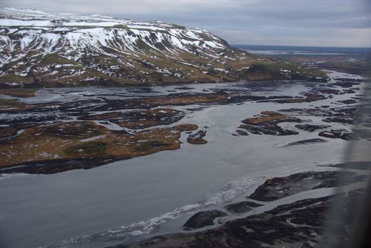
Skaftá river bellow the Skaftárdalur valley
. - Photo 20.01.2014 - Reynir Ragnasson - IMO
This Jökulhlaup in Skaftá river has its source in two subglacial caldrons, formed by geothermal activity under the Vatnajökull, a huge icecap overcoming several volcanoes
.
They drain an average of every two years , producing a
debacle which the flow reaches 1,500 cubic meters per second . And this is the East cauldron which
is responsible for the largest floods. His last drainage of September 2012.
In winter, the flow rate may be higher because the banks are icy
.
When the interval between two jökulhlaups is shorter, floods are
less important.
Various dangers accompany these floods, and it
is advised not to approach the glaciers during these alerts.
Hydrogen
sulphide is released by the water coming out of the cap of Vatnajökull. The concentrations of this gas are particularly important at the edge of the glacier, and it can reach lethal levels
.
Cracks can develop
rapidly near ice cauldrons and where the waters pierce the surface.

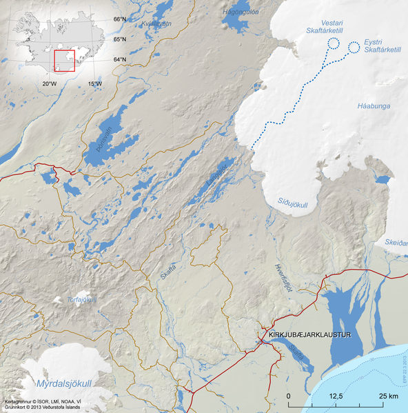 Localisation of the two cauldrons under the Vatnajökull and the way
out to the Skaftá river, SW of the glacier.
Localisation of the two cauldrons under the Vatnajökull and the way
out to the Skaftá river, SW of the glacier.
Map © Isor , LMI , NOAA, VI / via
Icelandic Met Office .
Some important jökulhlaups :
- In 1996, Grímsvötn
, it reached a peak of 45,000 m3/ s. ( greater than the flow of the
Mississippi ) over a width of fifty kilometers and a water depth of three to five meters to 23 h., time of maximum flood.
- The
eruption of Eyjafjallajökull in 2010 caused a significant melting of ice which causes jökulhlaups with a maximum flow rate of between 2,000 and 3,000 m3/ s.
 Jökulhlaup consecutive of the
subglacial eruption of Eyjafjallajökull , 14.10.2010 - Reuters photo archive
Jökulhlaup consecutive of the
subglacial eruption of Eyjafjallajökull , 14.10.2010 - Reuters photo archive
The debacle in Skaftá river
is currently declining , and has a comparable flux in size with a summer type discharge . This episode did not cause
damage.
Sources: Icelandic Met Office .
Thème Magazine - Hébergé par Overblog


/image%2F0935525%2F20221112%2Fob_03b696_ethiopie-scanner-bd-018.jpg)
/image%2F0935525%2F20221111%2Fob_1285d5_site-troglodyte-de-jonas-jmm.jpg)
/image%2F0935525%2F20221108%2Fob_d0f7fc_site-troglodyte-de-jonas-jmm.jpg)
/image%2F0935525%2F20221110%2Fob_af1829_puy-mary-2-jmm-1-28-10-2022.jpg)