
Actualité volcanique, Articles de fond sur étude de volcan, tectonique, récits et photos de voyage
Par Bernard Duyck
The villagers of Telina in the Marovo Lagoon in the Solomon Islands, live in fear of their paradise invaded by debris from an eruption of the submarine volcano Kavachi.

Solomon Islands - Marovo Lagoon - photo Magnificent destination Besttourism

Solomon Islands - the island Vangunu and lagoon Marovo - doc. Nasa
The Global Volcanism Program reports that a NASA satellite spotted on 29 January 2014 a plume of discolored water to eastern side of Kavachi, probably formed by dissolved gases and lava fragments.
Last month, disorders and swirling waters indicating the location of the seamount were noticed, and some fragments from the volcano were stranded on islands in the lagoon ... these signs are increasing local fears to see the activity travel to this area.
The villagers asked the authorities, yet minimize the events, to visit Marovo and investigate the situation.

Kavachy eruption in April 2007 - photo Today Images
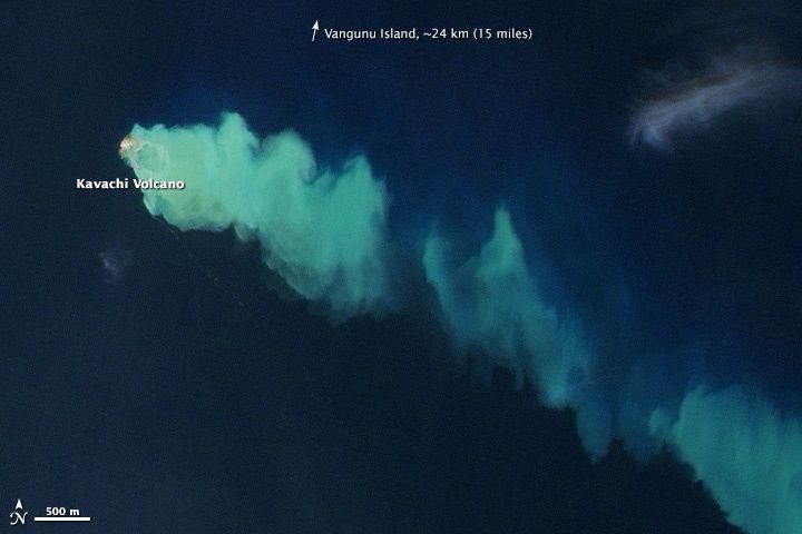
Kavachi - January 2014 eruption - doc. NASA EO-1 Ali 29/01/2014
The Seamont Kavachi, also called " Rejo te Kvachi " / " Kavachi's oven ", is located south of the Vangunu island, only 30 km. north of the site of the subduction of the Indo-Australian plate beneath the Pacific plate.
This submarine basaltic to andesitic volcano has produced since its first recorded eruption in 1939, during different subaerial eruptions and phreatomagmatic explosions, no less than eight ephemeral islands.
In the 21st century, four eruptions were observed: 1999 to August 2003, March 2004, April 2007 and January 2014 (GVP)
The Australian CSIRO / Commonwealth Scientific and Industrial Research Organization described in 2000, and in 2002, a conical shape relief with a basal diameter of 8000 meters, rising to 1000-1200 m from the depths north and more south side . The summit of Kavachi is seen between 60 meters below the sea level and the surface, depending on the activity.


Left, map of Marovo lagoon - right, bathymetries of Kavachi Seamont - doc. CSIRO - GVP - a click to enlarge.
Thème Magazine - Hébergé par Overblog


/image%2F0935525%2F20221031%2Fob_614820_2022-10-30-18h33-wit-gunung-ibu-p.jpg)
/https%3A%2F%2Fi.ytimg.com%2Fvi%2FoOCJ-5qxdO8%2Fhqdefault.jpg)
/image%2F0935525%2F20221029%2Fob_ff7a2c_2022-02-28-22h06-utc-pavlof-sat-wor.png)
/image%2F0935525%2F20221028%2Fob_fb9420_2022-10-26-survol-du-cotopaxi-par-le-f.jpg)