
Actualité volcanique, Articles de fond sur étude de volcan, tectonique, récits et photos de voyage
The Phlegraean Fields of the Sicily Sea consists
of a group of submarine volcanoes that are built in a depression located at 1000 m. depth in the Strait of Sicily, between his SW coast and the tip NE of Tunisia. They formed banks covered with cones , some of which grow up to close to the
sea level.
 Schéma
bathy-morphological of the strait of Sicily - General Bathymetric Chart da modificato of the Oceans 2003 - doc . INGV
Schéma
bathy-morphological of the strait of Sicily - General Bathymetric Chart da modificato of the Oceans 2003 - doc . INGV
Southwest of the Phlegrean fields , the
island of Pantelleria - to the south , the island of Linosa . (FL : Fossa di Linosa )
The Banco Graham,
still largely unknown and unmonitored, point to only 6.9 meters below the sea level. The first
exploration dated from 1890 by the Italian Hydrographic Institute .
In 1925 , teams from the research vessel "Admiral Magnaghi I " confirms the existence of the bank, 37 ° 09 ' N - 12 ° 43' E, with a summit of 30m ² at a depth of between 8 and 12
meters. New explorations by the
Hydrographic Institute in 1989 and 2002 show no changes in bathymetry.
 Ferdinandea island at its greatest extent in 1831 - doc
. taken from the Journal of the Ship Il Gustavo
Ferdinandea island at its greatest extent in 1831 - doc
. taken from the Journal of the Ship Il Gustavo
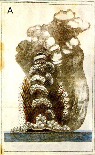 The eruption of Ferdinandea in 1831 , of Surtseyan type with cypressoïds clouds -doc.
C.Gemellaro / INGV
The eruption of Ferdinandea in 1831 , of Surtseyan type with cypressoïds clouds -doc.
C.Gemellaro / INGV
Submarine eruptions were reported at various times in ancient literature during the first Punic War ( War between Rome and Carthage between 264 and 241 BC) , and between 17 ° and 20 °
centuries. Three times, an ephemeral island formed during eruptions in 1701 , 1831 and
1863.
After its emergence in 1831 , the eclipse island reaches a considerable size (5 km . circumference and 65 m. height) , and is claimed in turn by the English, French , Spanish and Italians ...
of where its many names : Graham, Ferdinandea ,
Julia, Sciacca, or Proserpine island. The United Nations
Convention on the Law of the Sea (Montego Bay 1982) finally assigns the rights of the area to Italy on geographical territorial basis.
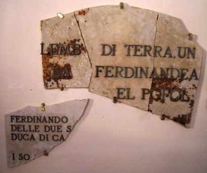 The remains of the original plate,
where it is written " " Questo lembo di terra una volta isola
Ferdinandea era e sara sempre del popolo siciliano ... Ferdinando di Borbone, Delle due Sicilii, Duca di Castro ..."."
- It was replaced by a new one in 2002. - Doc . Summitpost .
The remains of the original plate,
where it is written " " Questo lembo di terra una volta isola
Ferdinandea era e sara sempre del popolo siciliano ... Ferdinando di Borbone, Delle due Sicilii, Duca di Castro ..."."
- It was replaced by a new one in 2002. - Doc . Summitpost .
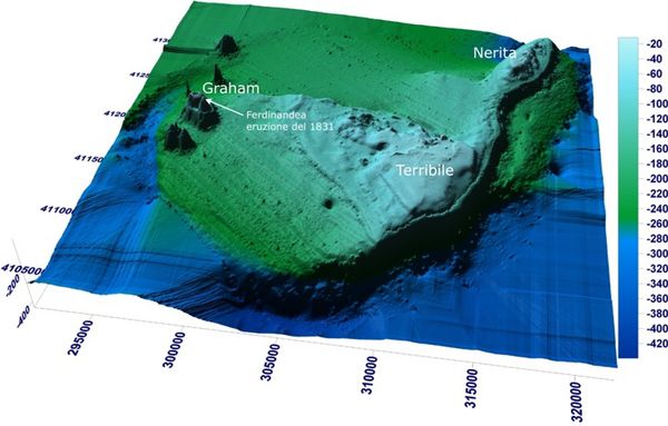 Image 3D bathymetric of Empedocles , with Banco
Graham ( or Ferdinandea ) to the west, to the east, the Banco Terribile and the Banco Nerita to the northeast . - Doc . INGV
Image 3D bathymetric of Empedocles , with Banco
Graham ( or Ferdinandea ) to the west, to the east, the Banco Terribile and the Banco Nerita to the northeast . - Doc . INGV
In 2006, the INGV indicates that Ferdinandea island could be part of a huge underwater volcano, 30 km to 25 , up to iron horse , named Empedocles , named
after the philosopher born in Agrigento and death on Etna ... Ferdinandea is the name given to the
summit of the volcano Empedocles . On this occasion , Enzo Boschi , president of
the INGV , said "the existence of such a volcanic group is not cause for concern ."
Empedocles,
of area comparable to that of Etna but with a more modest height, poses no immediate danger, its activity is limited to the emission of volcanic gases .
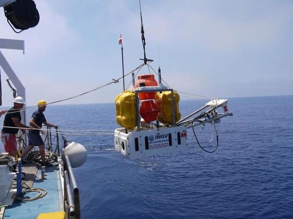 Launching of
the ROV of INGV on the Phlegrean fields of the Sicily sea - doc . INGV
Launching of
the ROV of INGV on the Phlegrean fields of the Sicily sea - doc . INGV
The volcanic system
includes a dozen buildings in a radius of 5 km., of varying sizes, with diameters between 50 and 1,500 m. These
buildings are aligned NW-SE in the Sicily Channel .
The cone responsible for the eruption of 1831 is part of a device consisting of two coalescing cones on a common basis, elongated NW- SE, and their apex are 600 m apart . The
building NW of Ferdinandea it has a frustoconical shape and a large crater, which fed lava flows that have invaded the floor at a depth of over 200
m. In the center, we see the remains of another crater rim . Its north-east side houses an active
field of fumaroles
 A
: Map of Banco Graham, with coalescing buildings - B: Ferdinandea to the right - the other cone : in 1: the edge of the crater - 2 : lava flows - 3 : edge a second crater -
4 : signs of intra- cratéric activity - in 5 : field of fumaroles - 6 : another building in horseshoe, having within it a small regular cone. - Doc . INGV
A
: Map of Banco Graham, with coalescing buildings - B: Ferdinandea to the right - the other cone : in 1: the edge of the crater - 2 : lava flows - 3 : edge a second crater -
4 : signs of intra- cratéric activity - in 5 : field of fumaroles - 6 : another building in horseshoe, having within it a small regular cone. - Doc . INGV
To the east of Ferdinandea group, the Banco Terribile rises to 20
m. subsurface and northeast , the Banco Nerita is only 16.5
m. below the sea level .
During
the exploration campaign , precise sonar survey has identified nine distinct craters. In addition to samples of rocks and gases, three seismic stations were installed on the seabed.
Pinne is a cone , located in the Phlegrean fields of the Sicily
sea,
and known for four historic eruptions during the First Punic War, circa 253 BC. , in
October 1846 ( VEI 2), in 1867 and the last in September 1911, but uncertain.
Sources :
- Global Volcanism Program - Campi Flegrei Mar Sicilia
- INGV Catania - Isola Ferdinandea - link
- Isola Ferdinandea ... il blog - link
- Sur ce blog, Ferdinandea - Pantelleria - Pantelleria et Linosa
Thème Magazine - Hébergé par Overblog


/image%2F0935525%2F20221112%2Fob_03b696_ethiopie-scanner-bd-018.jpg)
/image%2F0935525%2F20221111%2Fob_1285d5_site-troglodyte-de-jonas-jmm.jpg)
/image%2F0935525%2F20221108%2Fob_d0f7fc_site-troglodyte-de-jonas-jmm.jpg)
/image%2F0935525%2F20221110%2Fob_af1829_puy-mary-2-jmm-1-28-10-2022.jpg)