
Actualité volcanique, Articles de fond sur étude de volcan, tectonique, récits et photos de voyage
Among the many volcanoes that make up Mexico , there are three groups of volcanic islands located in the Pacific Ocean , off the continental shelf : the
Revillagigedo Islands, Guadalupe Island and Rocas Alijos .
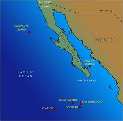 Location of Guadalupe Island to the NW and the Revillagigedo Islands south of the map.
Tectonics of this area is complex and related, at least for the Revillagigedo Islands, to the Clarion fracture, located west of the meeting point between the
Pacific, Cocos and Ribera plates.
The Clarion Fracture Zone was discovered in
1949 by teams of U.S. ship
Navy Serrano. It stretches 5,200 km from its western end , near a group of seamounts located south of Hawaii to the base of the continental slope off the coast of Puerto Vallarta in
Mexico.
Current magnetic variations datas, still incomplete, suggest that the floor along the fracture is produced by the expansion of the ocean floor from at least 80 Ma , which is still ongoing.
 The fracture zones from the north-west of the United States to Mexico - the remains of the Farallon plate are colored in olive green - the coastline is a fine little visible
line.
The fracture zones from the north-west of the United States to Mexico - the remains of the Farallon plate are colored in olive green - the coastline is a fine little visible
line.
Doc. The San Andreas fault system - USGS / William P. Irwin
The Clarion fracture is one of many fracture zones extending north of the American continent to Mexico , and reflect the same tectonic history : they were all formed by the expansion of Pacific -
Farallon system in the Cretaceous, and form groups according to changes in the direction
of plate movements.
 Guadalupe island - Captain Albert
E.Theberge Photo / NOAA Corps
Guadalupe island - Captain Albert
E.Theberge Photo / NOAA Corps
The Guadalupe island, located
241 km off the coast of the peninsula of  Baja California is composed of overlapping oceanic shield volcanoes, which are formed on an extinct ridge.
The volcanic rocks consist of olivine basalt and trachyte .
Baja California is composed of overlapping oceanic shield volcanoes, which are formed on an extinct ridge.
The volcanic rocks consist of olivine basalt and trachyte .
The island is
35 km long and 9.5 km wide. The volcanic chain reaches to the north, at Mount Augusta 's youngest volcano, a height of 1298 meters. At the southern tip , stands El Picacho , peaking at 975 meters.
The northern
part has fertile valleys and wooded , while the southern part is barren coast consists of rocky cliffs and loose blocks facing him. Two prominent islets are located 3 miles southwest of Guadalupe , separated by a
space called Tuna Alley.
Photo sat. Guadalupe island - doc . evs -islands
Rocas Alijos or Escullos Alijos ,
refers to a group of islets, rocky and steep , located 300 km. west of the continent , at coordinates 24 ° 57 N.
- 115 ° 44 W.
The three main islets are called - South rock , 34 meters high and 14 meters in diameter - Middle rock , 18 meters high and 10 meters in diameter - North rock , 22 meters high and 12 meters in
diameter. Other rocks are either submerged or so low that only reveal the wave
troughs .
 Rocas Alijos - South and Middle rocks - Photo Lt. Deborah Barr / NOAA Corps
They are included on the maps since 1598 , the
first description was made in 1704 by the pirate John Clipperton .
 Rocas Alijos map - from THE MARINE BIRDS OF ROCKS
Alijos , MEXICO ROBERT L. PITMAN , National Marine Fisheries Service
Rocas Alijos map - from THE MARINE BIRDS OF ROCKS
Alijos , MEXICO ROBERT L. PITMAN , National Marine Fisheries Service
Sources:
- Global Volcanism Program - Barcena
- USGS - The San Andreas fault system - by
William P. Irwin / USGS
- Photos NOAA Corps.
Thème Magazine - Hébergé par Overblog


/image%2F0935525%2F20221112%2Fob_03b696_ethiopie-scanner-bd-018.jpg)
/image%2F0935525%2F20221111%2Fob_1285d5_site-troglodyte-de-jonas-jmm.jpg)
/image%2F0935525%2F20221108%2Fob_d0f7fc_site-troglodyte-de-jonas-jmm.jpg)
/image%2F0935525%2F20221110%2Fob_af1829_puy-mary-2-jmm-1-28-10-2022.jpg)