
Actualité volcanique, Articles de fond sur étude de volcan, tectonique, récits et photos de voyage
Par Bernard Duyck
Based on satellite imagery, the VAAC Tokyo reported on November 20, 2013 / 7:17 UTC that a surtseyan eruption starts (from an estimated depth of -50 m), feeding a plume from a height of 600 meters, emerging about 500 meters south of Nishino-shima.
On 21 November, the Japan Coast Guards / JCG and the Japan Meteorological Agency / JMA notes that the "new island" is 200 meters in diameter. Photos show the plume and ash / rocks forcefully expelled from the crater.

Cypressoïde plume and water vapor off the Nishino-shima volcano on 11/20/2013 - hydromagmatic phase of the surtseyan eruption - photoGetty pictures

Nishino-shima and the site of the eruption November 20, 2013 - photo Japan Coast Guards

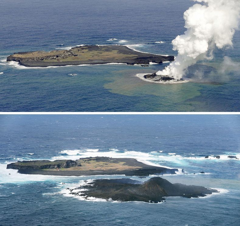
Nishino-shima, the 11/21/2013 - formation of a tuff / scoria cone - projections of bombs and gas / ash /steam plume - photo Japan Coast Guards via Japan Daily Press
From November 24, the Coast Guard reported that the lava comes out of the crater.
The island continues to build in December so that the 24.12, only a small channel separates the new Niijima of Nishino-shima, filled with water discolored in orange. On the map of expansion by the JCG, we can see how the island has increased between 13 and 24 December 2013.

Nishino-shima - The 24/11/2013, aerial phase of the eruption: the strombolian explosive activity accompanied by a plume of ash and lava - photo Japan Coast Guards


3D views of Nishino-shima - the tip of the volcano is in green bronze - doc MLIT - a click to enlarge
Progression of the new island between November and 12/21/2013 - photo Kyodo / AP

Nishino-shima, left, separated from Niijima, right, through a narrow channel - Territorial fusion is coming, and the appellation "volcano" could be changed to "adventitious cone" - 12.24.2013 / JCG.
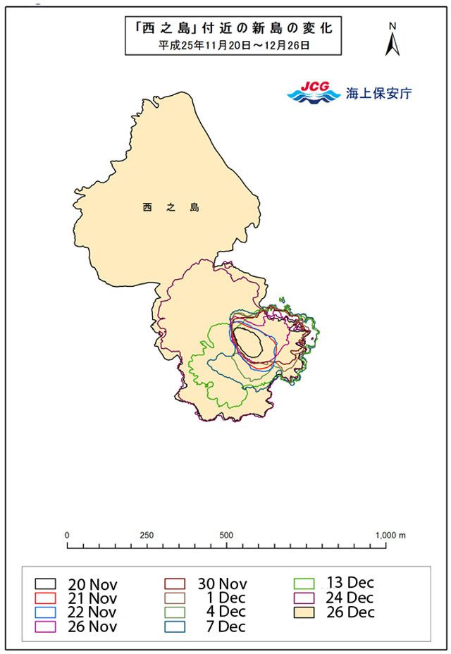
Map of the progression of lava flows and the extension of the new island, between November 20 and December 26, 2013 - Doc JCG
On December 26, 2013, the Japan Coast Guard confirms that the two islands are joined. The closure by coalescence of the lava flows left a small lake, of temporary existence, which eventually disappear through evaporation. As the new island merged with the former, it will again name Nishinoshima.
December 26, 2013, Niijima joined Nishino-shima - photo JCG

December 26, 2013, Niijima joined Nishino-shima - photo JCG
An aerial inspection by the Geological Survey of Japan on February 28, 2014 shows emissions of gas and steam at the two cones of the last eruption.The flows in all directions reach the sea to the east, south-southeast and west-northwest.
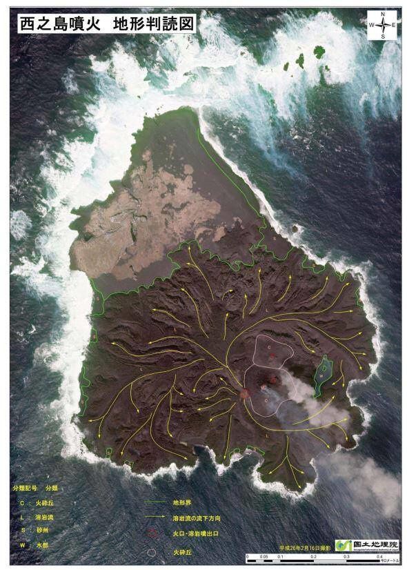
Situation on 16 February 2014, lava is flowing in all directions - Doc. Japan Coast Guards

Nishino-shima: 28/02/2014 Inspection by the Geological Survey of Japan

Nishino-shima: 28/02/2014 Inspection by the Geological Survey of Japan - the two cones are degasing and a small lake, imprisoned by lava flows joining, is in evaporation phase.
After a period of lava flows in all directions, the active craters, at the number of 3 in August, continues to spit lava at a rate of 200,000 cubic meters each day ... and lava accumulates mainly eastward.

Nishino-shima on 03/06/2014 - photo JCG / AIST
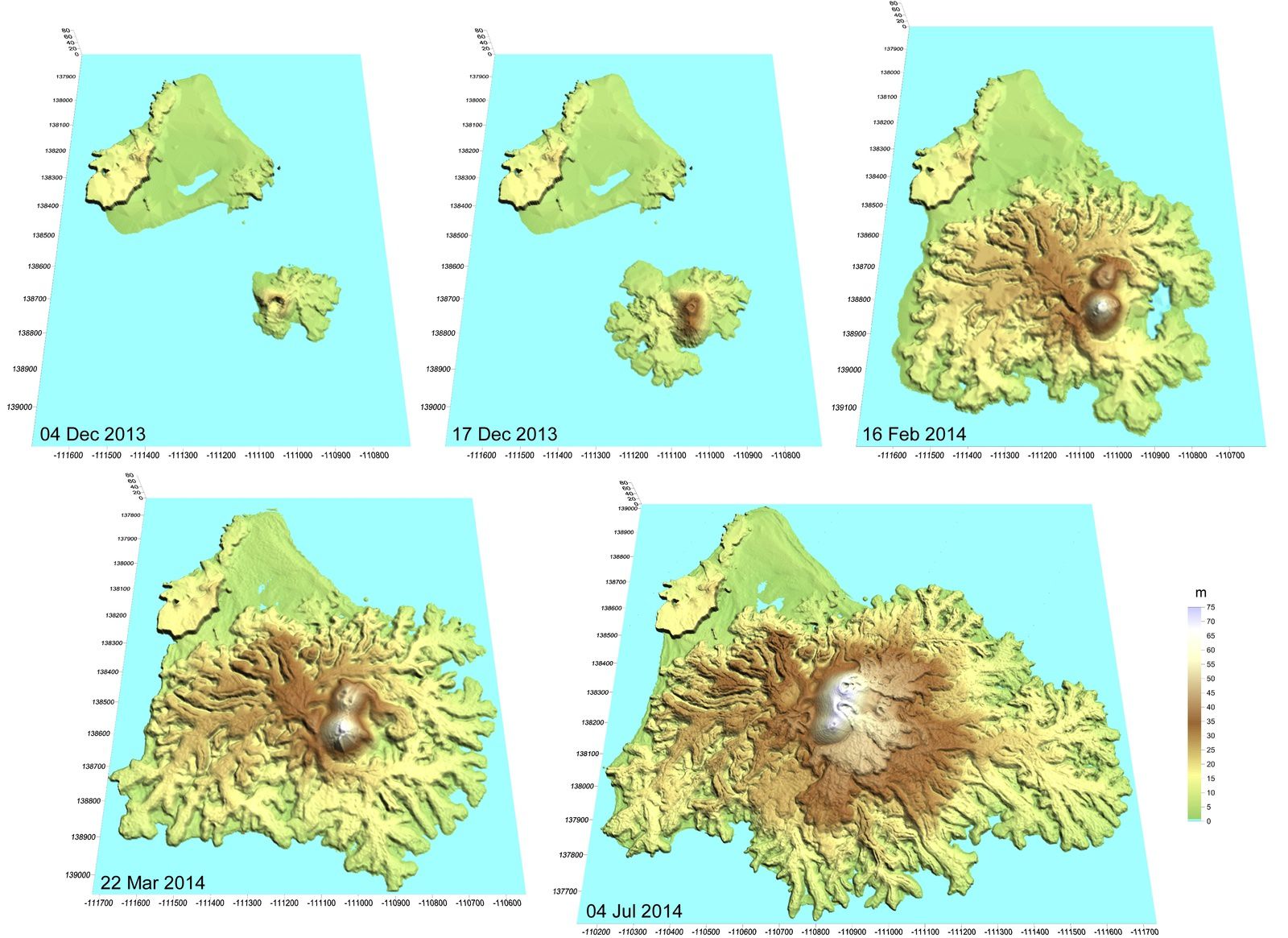
Evolution between December 4, 2013 and July 4, 2014 - Doc Arukazan.jp

Nishino-shima on 08/26/2014 - photo JCG
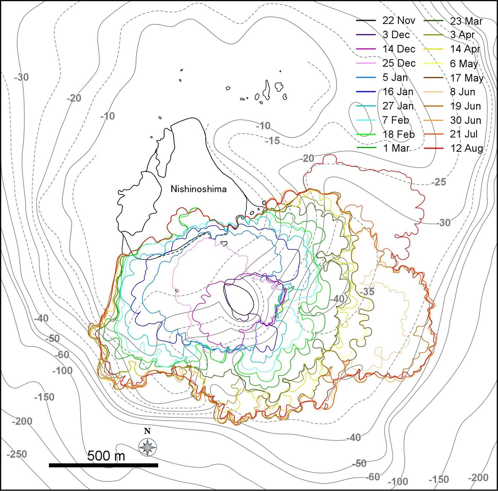
Map the extension of cast between November 22, 2013 and August 12, 2014 - Doc. eri.u-tokyo
Uncertainties are issued by scientists about the stability of the building, and the risk of flank collapse, current volcanic islands is concerned.

Nishinoshima - evolution and distribution of lava flows - On the cross section, you can see an accumulation of the lava flows to the east (right side of the diagram) - doc eri.u-tokyo
The lava flows will then move towards the northeast and in September, to the north and west ... engulfing the former island of which remain only a thin plot.
The Coast Guard measured (on aerial photos) the area of the island, which reached 1.89 km² on October 16, nearly nine times the size of the volcano had the first time he was seen.
For Professor Setsuya Nakada, a volcanologist of the Seismic Research Institute of the University of Tokyo, "the eruption will last a few years."

Nishino-shima: the 16/10/2014, the lava almost entirely covered the former island - photo JCG

Nishino-shima: the rest of the former island and the active cone, the 11/15/2014 - Mainichi Photo
Sources:
- Japan Coast Guard
- Geological Survey of Japan
- Japanese media
Thème Magazine - Hébergé par Overblog


/image%2F0935525%2F20221018%2Fob_28398d_traces-ds-depot-de-surge-er-avell.jpg)
/image%2F0935525%2F20220314%2Fob_7fda0c_2022-03-13-06h43-reventador-webca.jpg)
/image%2F0935525%2F20201213%2Fob_d5dcbe_2020-12-10-arbre-petrifie-stonisi.jpg)
/image%2F0935525%2F20201122%2Fob_5dc433_nov-21-2020-2-parco-archeologic.jpeg)