
Actualité volcanique, Articles de fond sur étude de volcan, tectonique, récits et photos de voyage
Between North island / New Zealand and the Fiji archipelago, various structures are parallel : the Colville and Kermadec ridges, separated by Havre Trough, and the Kermadec Trench .
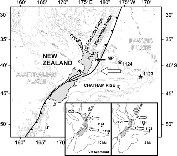 Tectonic of the Pacific and Australian plates around New
Zealand, now and in the past: 10 and 2 Ma
Tectonic of the Pacific and Australian plates around New
Zealand, now and in the past: 10 and 2 Ma
NVA : Northern Volcanic Arc ;
TVZ :Taupo Vocanic Zone , CVZ: Coromandel Volvanic Area; CR: Corville ridge ; KR: Kermadec Ridge .
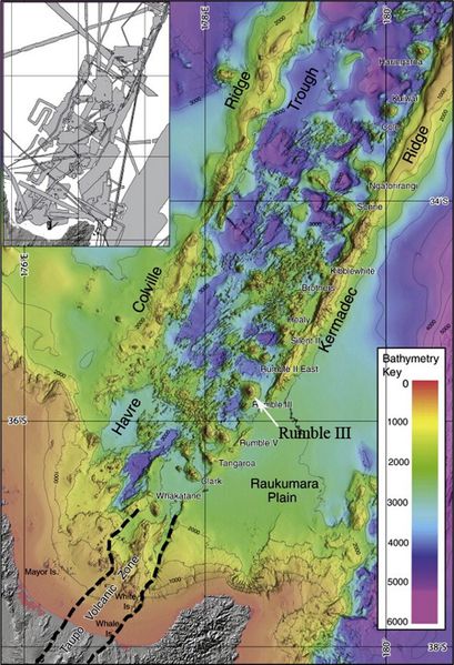 General bathymetric image of
Corville and Kermadec ridges, made during the exploration of the Kermadec Ridge by NOAA in 2005 - doc . GVP
General bathymetric image of
Corville and Kermadec ridges, made during the exploration of the Kermadec Ridge by NOAA in 2005 - doc . GVP
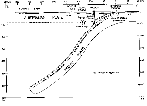 Subduction of the Pacific plate beneath
the Australian plate and dive up to 600 km. deep -
In sub-surface, from right to left : the Kermadec Trench , Raoul Island in the Kermadec arc, the Havre Trough, the Colville ridge and the South Fiji Basin - doc . GNS Science
Subduction of the Pacific plate beneath
the Australian plate and dive up to 600 km. deep -
In sub-surface, from right to left : the Kermadec Trench , Raoul Island in the Kermadec arc, the Havre Trough, the Colville ridge and the South Fiji Basin - doc . GNS Science
Regional tectonics
is related to the subduction of the Pacific plate beneath the Australian plate and the formation of marginal basins .
A thorough
bathymetry of the Kermadec ridge was performed in the past, by cons the Colville parallel ridge has been little studied. Yet it is an important structure , with peaks dominate the floor on
either side of 2,000 meters.
This has just
been done by teams of GNS Science, in collaboration with NIWA - National Institute of Water and Atmospheric Research - and Oregon State University.
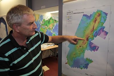
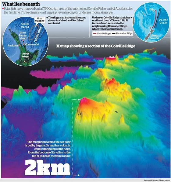 Localisation of the Colville ridge and first 3D picture - doc . GNS Science / in The New Zealand Herald
It
validated the hypothesis that the Colville and Kermadec ridges were originally united before a rift, the Havre Trough, separates them there are a few million years ago .
Morphological differences were observed between the two ridges and interpreted as a reflection of collapse phenomena , lifting and significant erosion on the Kermadec Ridge, contrasting with
lower uplift and erosion on the Colville ridge.
New data
shows more than the Colville ridge is not exclusively volcanic , rocks found forming a mix of sedimentary and volcanic rocks .
 Dr in marine geology Cornel
de Ronde commenting on the new bathymetric map of the Colville ridge - photo GNS .
Dr in marine geology Cornel
de Ronde commenting on the new bathymetric map of the Colville ridge - photo GNS .
We found numerous faults crossing the area , most
oriented NE-SW , and deepening to the E . These
issues suggest a presence of minerals on the ocean floor, reassembled along faults from hot fluids containing various metal compounds in solution .
The search for these metals will be carried out by
Germans and Japanese research institutes, in collaboration with researchers of New Zealand , and through autonomous underwater vehicles in 2014-15.
Sources :
- The New Zealad Herald - Sea floor map result stuns experts - link
- GNS Science - Origin of seabed more complex than scientists first imagined - link
- Morphology and Evolution of the Remnant Colville and Active Kermadec Arc Ridges South of 33°30′ S - by Ian C.Wright - link
- Subductions et ouvertures océaniques dans le Sud-Ouest Pacifique - Oceanic subductions and active spreading in the Southwest Pacific - by
Etienne Ruellan and Yves Lagabrielle
Thème Magazine - Hébergé par Overblog


/image%2F0935525%2F20221112%2Fob_03b696_ethiopie-scanner-bd-018.jpg)
/image%2F0935525%2F20221111%2Fob_1285d5_site-troglodyte-de-jonas-jmm.jpg)
/image%2F0935525%2F20221108%2Fob_d0f7fc_site-troglodyte-de-jonas-jmm.jpg)
/image%2F0935525%2F20221110%2Fob_af1829_puy-mary-2-jmm-1-28-10-2022.jpg)