
Actualité volcanique, Articles de fond sur étude de volcan, tectonique, récits et photos de voyage
The Kapoho eruption is linked to changes that will take place at the summit of Kilauea.
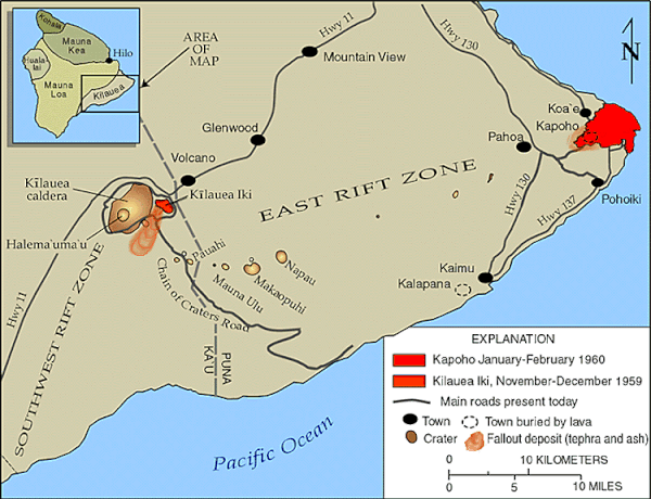 Kilauea - map of eruptions 1959 to 1960 - and location of the summit
craters , and the Kapoho area. - Doc . USGS - HVO
Kilauea - map of eruptions 1959 to 1960 - and location of the summit
craters , and the Kapoho area. - Doc . USGS - HVO
Its development has obscured the subsequent deflation of lava
fountains from Iki Crater in late 1959 .
 Kilauea -
erupting Kilauea Iki summit crater and fountain of lava and pumice on 29.11.1959 at 10:30 - photo JPEaton / USGS - HVO
Kilauea -
erupting Kilauea Iki summit crater and fountain of lava and pumice on 29.11.1959 at 10:30 - photo JPEaton / USGS - HVO
And on January 17
, four days after the onset of the Kapoho eruption, the summit of Kilauea begins to deflate, following the movement of the mass of magma to the rift zone .
From January 23 , small superficial
earthquakes mark the summit of Kilauea, and rock collapses occur. At the end of January, there are a thousand daily
shaking on the floor of the caldera, one hundred noticeable. Old
cracks widen around the crater Halema'uma'u , while new form ... and avalanches of blocks from
the walls of the crater become common.
On February 5 , new fumaroles areas appear around the crater
Halema'uma'u .
The collapse of the crater floor begins on the night of 6 to 7 February . Strange sounds come from the explosion crater, accompanied by that
of the bursting of rocks and avalanches.
 Kilauea
- Halema'uma'u crater summit - Main collapse of 7 February 1960, the lava lake formed during the eruption in 1952 come out of a circular fracture and fills the well of 300 meters in diameter -
photo JPEaton / HVO - USGS
Kilauea
- Halema'uma'u crater summit - Main collapse of 7 February 1960, the lava lake formed during the eruption in 1952 come out of a circular fracture and fills the well of 300 meters in diameter -
photo JPEaton / HVO - USGS
Observation at dawn reveals a depression in " soup plate " and cracked : cracks have apparently opened under the lava lake of the eruption of 1952, and lava still present was drained .
Depression deepened until it reaches 30 m. depth, as
measured by the observatory.
To 11:51 , a circular area with a diameter of 300
meters begins to widen, at high speed, in the central portion of the depression. The well
collapse deepens over 60 meters in 9 minutes only. Around noon, the viscous lava begins to emerge from a circular
fracture in this well : it comes from the lava lake in 1952.
During the afternoon of day 7 and 8 February , the lava accumulates in a
reservoir located 20 m. deep in the well. This extrusion of lava will continue slowly and intermittently until February 11
.

A second well of collapse
formed as the end of the afternoon, the 9.02, southwest of the main well. It grows in 10 minutes, without encountering still liquid lava.
On 12 February, a major
earthquake marks the summit and opens many cracks in the upper part of the fault system Koa'e . On March 7 , a shallow earthquake causes damage to homes in the park.
On March 11, a third and final collapse
occurs on the Halema'uma'u crater floor . In 25 minutes, a well 90
meters on 120 and 30 meters deep , formed in the north-eastern part of what remains of the floor of the eruption in 1954 not collapsed. During the night, the lower wall of the new well is incandescent .

 Map
of the Halema'uma'u crater of Kilauea after the collapse of 1960 - the central well is the most obvious, the second well is in the SW part , and that of March 11 is located in the NE corner of
the crater outside of the "plate " - Doc. by Richter et al 1970 / USGS - HVO
Map
of the Halema'uma'u crater of Kilauea after the collapse of 1960 - the central well is the most obvious, the second well is in the SW part , and that of March 11 is located in the NE corner of
the crater outside of the "plate " - Doc. by Richter et al 1970 / USGS - HVO
The
1959-1960 eruption of Kilauea is the first eruption which many residents of Big island will remember, then time helping, only do remember that through photos and writings.
But this kind of catastrophic episode will definitely still happen ... do not forget the lesson .
Sources :
- HVO / éruption sommitale du Kilauea Iki du 14 novembre au 20 décembre 1959 - link
- HVO / éruption Kapoho de 1960 - link
Thème Magazine - Hébergé par Overblog


/image%2F0935525%2F20221112%2Fob_03b696_ethiopie-scanner-bd-018.jpg)
/image%2F0935525%2F20221111%2Fob_1285d5_site-troglodyte-de-jonas-jmm.jpg)
/image%2F0935525%2F20221108%2Fob_d0f7fc_site-troglodyte-de-jonas-jmm.jpg)
/image%2F0935525%2F20221110%2Fob_af1829_puy-mary-2-jmm-1-28-10-2022.jpg)