
Actualité volcanique, Articles de fond sur étude de volcan, tectonique, récits et photos de voyage
The Barva volcano is a composite shield volcano , covering
1,500 square km and considered dormant .
Consisting of two calderas , one 15 km in diameter, the other 10 km, it is dotted with craters and parasitic cones. Near the top, a 800-meter wide crater contains a lake, the laguna del Barva . With its three
main peaks visible in the Central Valley , the local name is "Las Tres Marías " .
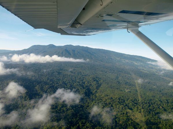
 Barva
volcano area between the Cetto Gongolona crater and the volcano Cacho Negro - Jean Pierre Bergoeing Photo / Red Sismologica Nacional Costa Rica
Barva
volcano area between the Cetto Gongolona crater and the volcano Cacho Negro - Jean Pierre Bergoeing Photo / Red Sismologica Nacional Costa Rica

Volcanoes of the Cordillera Central / Costa Rica : Poas , Barva , Irazu and
Turrialba . - Doc. Narod.ru
 Massif of Barva , seen from the south - Photo JP
Bergoeing / RSN
Massif of Barva , seen from the south - Photo JP
Bergoeing / RSN
This volcano is the origin of the large layer of
tuff Tiribí deposited in the Central Valley , there are 322,000 years.
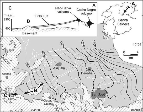 Contours of the summits
of Tiribi tuff (indications in meters above sea level ) - insert : cut from the Cacho Negro to Grande Tarcoles river canyon . - Wendy Card Pérez et al.
Contours of the summits
of Tiribi tuff (indications in meters above sea level ) - insert : cut from the Cacho Negro to Grande Tarcoles river canyon . - Wendy Card Pérez et al.
 Barva - a. the two calderas of Barva - b.
Caldera of Barva with the situation of recent buildings : the Cacho Negro and the top of Barva, overlapping by places the rim of the caldera ; the western
part of the caldera is strongly eroded - Map / geo.mtu.edu
Barva - a. the two calderas of Barva - b.
Caldera of Barva with the situation of recent buildings : the Cacho Negro and the top of Barva, overlapping by places the rim of the caldera ; the western
part of the caldera is strongly eroded - Map / geo.mtu.edu
This
ignimbrite is the most recent, the most extensive and well exposed in central Costa Rica : it covers an area of 820 km² with a volume of 25 km³ issued . The thickness of the top layer varies between 30 and 100 meters. On a geochemical level, tuff shows a composition
ranging from basaltic andesites to rhyolites , with a dominant trachyandesites . The
isopach attest to the benefits of source to the caldera Barva (upper panel) .
The responsible
eruption seems to have evolved from a Plinian type with extended pumice fallout towards a fountaining accompanied by pyroclastic flows .
In
the southwestern part of the Central Valley , the ignimbrite flowed into a narrow canyon , which may have acted as a pseudo- barrier and thickened deposits in the central depression
.
 Laguna del Barva - Photo Tillor 87 / Skyscrapercity
The eruption of the tuff Tiribí
reveals the danger posed by the Volcan Barva for the 2.4 million people living in the vicinity.
Although previous data suggest no historical activity for Laguna del Barva, and the thick forest cover does not seem to have been affected by a recent eruptive activity at Laguna Danta and other older craters, we can not rule the
possibility of an eruption of low intensity during the last millennium ...
Slag present northeast of Laguna del Barva appear recent , aged about 500 years
. Two kilometers north of Cerro Gongolona and to Porrosatí of Barva ,
hot springs exist. Norths in
the foothills of Barva , at a place called Camaquire remains a residual activity , characterized by sulfur springs and hot springs. One can also observe landslides in
crown down the Colonia Jesús María , with a solfataric activity and native sulfur deposits . In the ravines,
with evocative local names, "La Bomba " and " Cabro ", of hot water outlets were measured at an average temperature of 60 ° C.
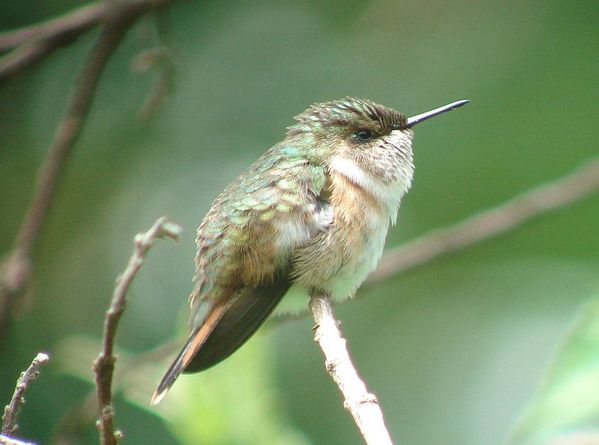 Volcano hummingbird - Selasphorus flammula - Colibri flammule - Photo Barva volcano
birdingcraft
Volcano hummingbird - Selasphorus flammula - Colibri flammule - Photo Barva volcano
birdingcraft
The Barva region is largely untapped in tourism. The coverage
by a primary forest, also called cloud forest , makes Braulio Carrillo National Park, a rich reserve of plants (600 species) and birds ( 515 species ), the rare Quetzal or the Volcano
hummingbird, endemic to Costa Rica and Panama . Hopefully , we came across the puma and the jaguar.
Sources :
- Red Sismologica Nacional costa Rica - Actividad eruptiva y potential del Volcan Barva
- The 322 ka Tiribí Tuff: stratigraphy, geochronology and mechanisms of deposition of the largest and most recent ignimbrite in the Valle Central, Costa Rica - by Wendy Pérez . Guillermo E. Alvarado . Phillip B. Gans
- Revista Geológica de América Central -
Rev. Geol. Amér. Central no.47 San Pedro de Montes de Oca dic. 2012
- Volcano-stratigraphy and tectonics of the Western Central Valley and Montes del Aguacate along road 27, Costa Rica
Thème Magazine - Hébergé par Overblog


/image%2F0935525%2F20221112%2Fob_03b696_ethiopie-scanner-bd-018.jpg)
/image%2F0935525%2F20221111%2Fob_1285d5_site-troglodyte-de-jonas-jmm.jpg)
/image%2F0935525%2F20221108%2Fob_d0f7fc_site-troglodyte-de-jonas-jmm.jpg)
/image%2F0935525%2F20221110%2Fob_af1829_puy-mary-2-jmm-1-28-10-2022.jpg)