
Actualité volcanique, Articles de fond sur étude de volcan, tectonique, récits et photos de voyage
In northern Kenya , Lake Turkana , also
called " Jade Sea " , is home to many volcanic landscape.
First known as Lake Rudolf , in honor of the Crown Prince of Austria, it was discovered by Europeans in 1888, and was renamed Turkana after Kenya's independence in 1975 , in honor of the largest
tribes living on its banks.
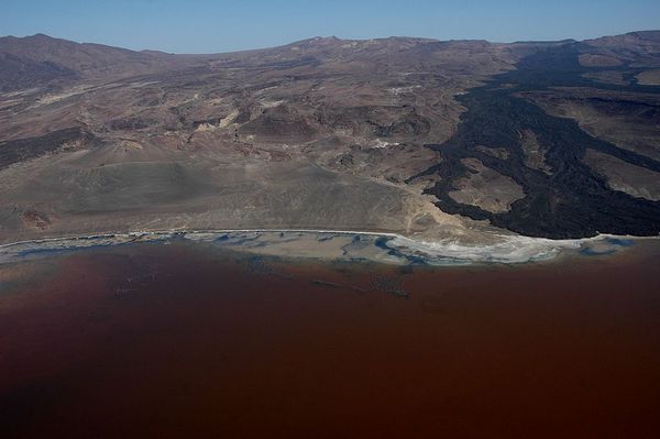
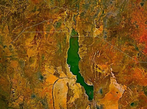 " The Jade Sea " - Lake Turkana encroach north of Ethiopia ( the border is thin overlay )
Satellite image via Wikipedia / Roke .
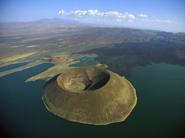 Nabuyatom volcano and the lava of the volcano Teleki / The barrier volc
. compl. / South of Lake Turkana / Von Höhnel
bay - Photo veselok.ru
Nabuyatom volcano and the lava of the volcano Teleki / The barrier volc
. compl. / South of Lake Turkana / Von Höhnel
bay - Photo veselok.ru
Lake Turkana was
at its peak here 9,000 years ; the lowest point was reached there 4,000 years ago , when he lost his major source and split into two entities. He found today an intermediate level, 80% supplied
by the Omo River which leads to the north and to the east, by the Turkwel river .
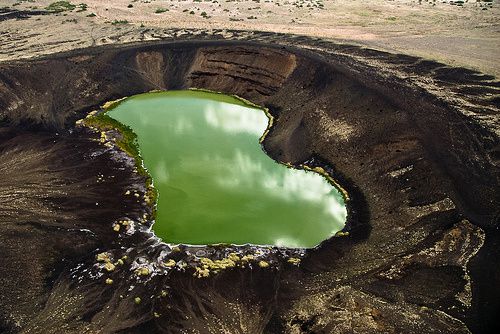
North Island is formed of a
collection of tuff cones , dated 3.25 Ma, 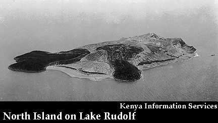 which exceed 220 m. the lake level .
In its center, a young tuff ring is filled with dark brown trachytic lava which overflowed on its east side.
which exceed 220 m. the lake level .
In its center, a young tuff ring is filled with dark brown trachytic lava which overflowed on its east side.
A fault line crosses the island from NE to SW., along which the geothermal activity is concentrated. Hot springs, fumaroles and sulfur springs are found in the southern part of North Island , 2 km long . In 2004, a geyser is described ... without activity report since.
Photo Oregonstate Univ.
/ Kenya Information Services.
Further south of Kenya, the Suguta river valley is separated from Lake Turkana by the Barrier volcanic complex, mainly trachytic , 15 km wide, and consists of
four overlapping shield volcanoes , from west to east , the Kalolenyang, the Kakorinya, the Likaiu East and Likaiu West .
 The
Barrier volcanic complex, between the Lake Turkana and the Suguta Valley - Photo GVP
The
Barrier volcanic complex, between the Lake Turkana and the Suguta Valley - Photo GVP
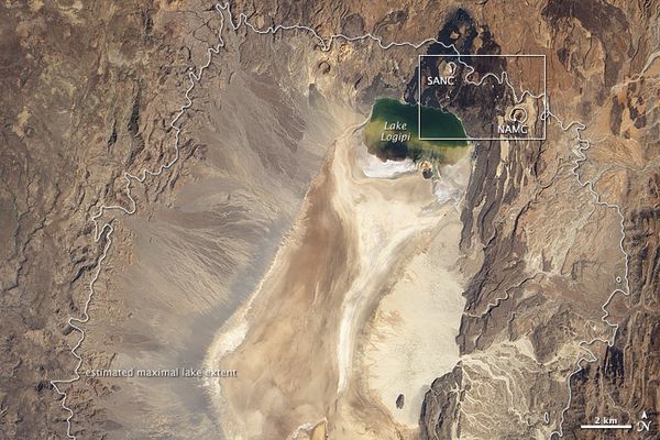 The
dry Suguta valley and the lake Logipi - the cinder cones SANC and NAMC are part of The Barrier complex - the fine white line marks the maximum extension of the paleo- lake Suguta - Photo NASA EO-
1 Ali 10.01.2011
The
dry Suguta valley and the lake Logipi - the cinder cones SANC and NAMC are part of The Barrier complex - the fine white line marks the maximum extension of the paleo- lake Suguta - Photo NASA EO-
1 Ali 10.01.2011
 Suguta valley -
volcanic structure with waters colored by algae - Photo Skyscrapercity / Y.Garcin
Suguta valley -
volcanic structure with waters colored by algae - Photo Skyscrapercity / Y.Garcin
There are a few thousand years this valley was filled by a paleo- lake ... since it has dried and is traversed by the seasonal river Suguta , which forms the temporary Alablad Lake , a dry lake
that combines north of the valley with Logipi lake.
The Suguta river passes a place called The Gap , flanked by two volcanoes. It is fed by hot springs flowing on both sides of the valley. One of them , the geyser Logipi was active until the
30s , it was 1.2 m in height. An expedition to this remote area found in
1990 only hot springs .
Logipi lake bordered by lava flows- Photo François -Olivier Dommergues / Flickr FO travel
 Volcanic outcrop with Logipi lake in foreground - Photo
wildencounters.net
Volcanic outcrop with Logipi lake in foreground - Photo
wildencounters.net
The Suguta Valley is home to the shield volcano
Namarunu, mainly trachytic.
He wears parasite cones and lava, dating from late Pleistocene and Holocene, where a basaltic effusive and explosive activity took place along the axis of the African Rift, characterized by
cinder cones, lava flows, sublacustres tuff rings, tuff cones and pillow lavas. A cinder cone forming the top of Namarunu issued olivine fluids basalts. The most recent eruption is dated there 3000 years ago, after the drying up of Lake Suguta .
Few pictures of geysers of this region , offset by the associated volcanoes ...
Kenya second part tomorrow .
Sources :
- Wondermondo - geysers of Africa - link
- Global Volcanism Program - North island
- Global Volcanism Program - The Barrier
- Global Volcanism Program - Namarunu
- Science direct - Late pleistocene-Holocene rise a,d collapse of Lake Suguta, northern Kenya rift - by Yannick Garcin & al.
- Potsdam Univ. - Suguta valley project - link
Thème Magazine - Hébergé par Overblog


/image%2F0935525%2F20221112%2Fob_03b696_ethiopie-scanner-bd-018.jpg)
/image%2F0935525%2F20221111%2Fob_1285d5_site-troglodyte-de-jonas-jmm.jpg)
/image%2F0935525%2F20221108%2Fob_d0f7fc_site-troglodyte-de-jonas-jmm.jpg)
/image%2F0935525%2F20221110%2Fob_af1829_puy-mary-2-jmm-1-28-10-2022.jpg)