
Actualité volcanique, Articles de fond sur étude de volcan, tectonique, récits et photos de voyage
The Banks Peninsula is located on the east coast of South Island / New
Zealand. Its surface is around 1,150 km ² and has many bays and two large ports.
 NZ - Banks Peninsula on South Island.
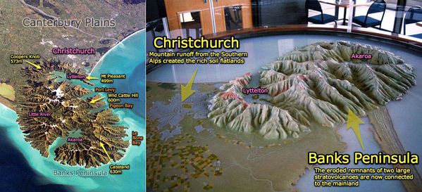 Left:
The Banks Peninsula and two large bays, corresponding to the craters of extinct volcanoes , Lyttelton to the north and Akaroa to the south - right : model of the Banks Peninsula and
his two volcanoes - Banner on the official site .
Left:
The Banks Peninsula and two large bays, corresponding to the craters of extinct volcanoes , Lyttelton to the north and Akaroa to the south - right : model of the Banks Peninsula and
his two volcanoes - Banner on the official site .
 Banks
Peninsula , with the greater Christchurch to the north and to the west, the Lake Ellesmere ( Waihora ) - NASA Landsat Photo 7 /
09.2001
Banks
Peninsula , with the greater Christchurch to the north and to the west, the Lake Ellesmere ( Waihora ) - NASA Landsat Photo 7 /
09.2001
According to volcanologists and NASA , this peninsula , which is named after the botanist of the expedition Cook, is made of two overlapping extinct volcanoes : the
Lyttelton volcano and the Akaroa volcano.
Since
their last activity, some six million years ago, these volcanoes have been heavily eroded , and their height decreased from 1,500 to 500 meters.
Breaks in the walls of the craters have opened the door, there 15,000 years ago during the post- glacial period to marine inlets and formed the bays housing the Lyttelton and Akaroa
ports. The
original island became a peninsula connected to the Canterbury plain, when during its geological history, she was joined by the growth of the floodplain .
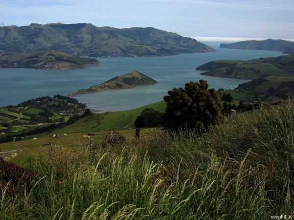 Banks Peninsula - Akaroa harbor , Akaroa volcano crater - photo Steephill tv
Approximately 10 km under the plains of Canterbury, is a large oceanic plateau basalt , called Hikurangi plateau , more than half was driven by subduction
beneath North Island and the Chatham Rise. The Hikurangi Plateau was formed , there are 122 million years , during the flood basalt known as the " Great Ontong Java" .
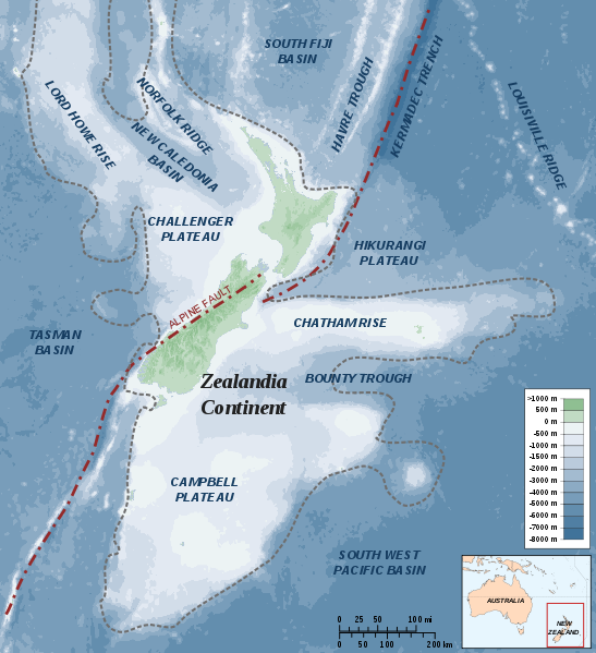 The southern continent New
Zealand - location of the Hikurangi Plateau and the two main New Zealanders islands - doc . Alexander Karnstedt /
Te Ara .
The southern continent New
Zealand - location of the Hikurangi Plateau and the two main New Zealanders islands - doc . Alexander Karnstedt /
Te Ara .
 Damage caused by
the earthquake in Christchurch - photo Landslide Blog / AGU
Damage caused by
the earthquake in Christchurch - photo Landslide Blog / AGU
 Deformations and
liquefaction consecutive to earthquakes - Christchurch area - photo gallery NZ Herald
Deformations and
liquefaction consecutive to earthquakes - Christchurch area - photo gallery NZ Herald
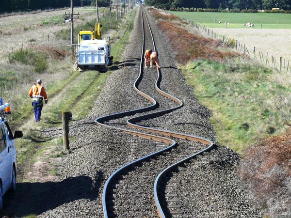
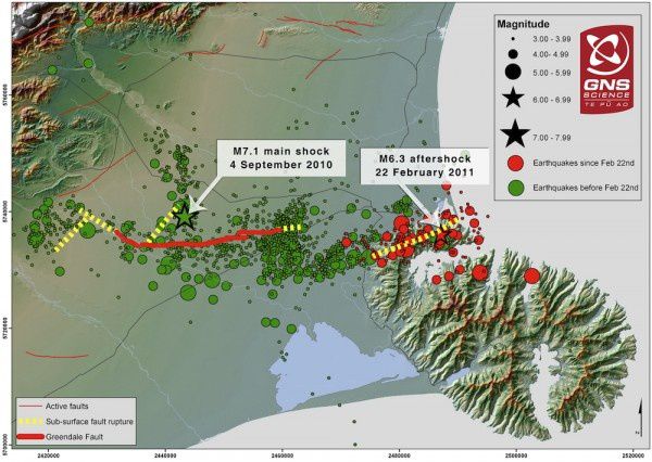
Analysis of seismic waves over 11,500 aftershocks consecutive to the 2010 earthquake that hit the Christchurch area, north of Banks Peninsula, and those related to earthquakes of 2011, led to a
3D mapping of the rocks underlying the plains of Canterbury.
Under the broken area by earthquakes, scientists have discovered a region considerably "weaker", suggesting extensive cracking ( 5 km ) of the greywacke * around the fault. This is not consistent with the usual
extent of cracking for earthquakes of this magnitude, which is of the order of several hundred meters . ( GNS Science / Martin
Reyners / Nature Geoscience 11/24/2013 ) ... and suggests that such earthquakes can lead to a general weakening of the crust.
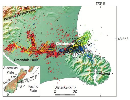 Map of
the Canterbury earthquakes sequence, near Christchurch NZ - Credit . Reyners , et al , Nature Geoscience.
Map of
the Canterbury earthquakes sequence, near Christchurch NZ - Credit . Reyners , et al , Nature Geoscience.
the star position the most important events and aftershocks associated in the same
color. - Red:
03.09.2010 / M7 earthquake and aftershocks - black : 22.02.2011 / M6 earthquake and aftershocks - blue: 13.06.2011 / M6 earthquake and aftershocks - green: earthquakes 23.12 .
2011 / M5, 8 & 5.9 and aftershocks.
Yellow rectangles highlight the fault planes.
 Map of the Canterbury earthquake sequence , near Christchurch NZ - doc . GNS Science
*: Greywacke
: (n. old German term minor) : clastic sedimentary rocks generally dark in color, with a relatively abundant cement (approx. 20 %). This is a arenite
. It is
rich in chlorite, clay minerals, with 30% or more of rock debris , it also contains grains of quartz , feldspar , some mica .
To follow: the volcanoes of Banks Peninsula .
Sources :
- GNS – the geology of New Zealand - link
- Ower amazing planet - Deadly New Zealand Earthquakes Weakened Earth's Crust – by C .Q .Choi - link
Thème Magazine - Hébergé par Overblog


/image%2F0935525%2F20221112%2Fob_03b696_ethiopie-scanner-bd-018.jpg)
/image%2F0935525%2F20221111%2Fob_1285d5_site-troglodyte-de-jonas-jmm.jpg)
/image%2F0935525%2F20221108%2Fob_d0f7fc_site-troglodyte-de-jonas-jmm.jpg)
/image%2F0935525%2F20221110%2Fob_af1829_puy-mary-2-jmm-1-28-10-2022.jpg)