
Actualité volcanique, Articles de fond sur étude de volcan, tectonique, récits et photos de voyage
The outstanding geological
sites have always been occupied by men, proximity to the volcanoes can not rest ... and for various reasons.
In the French Massif
Central, near Clermont-Ferrand, the basalt plateau of Corent dominates the Allier and control the access to the south to the fertile basin of Limagne.
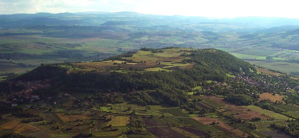 The Corent plateau - Photo Adcanaunos
From the
highest point of the plateau, 200 meters above the surrounding land, the field of vision is clear by about 15 km., making this site a strategic location.
Traces of occupation dating back to the Neolithic, to the Bronze Age - 11 and 10 Centuries BC - then the Iron Age- end 7 °/ early 6th century BC. The Gallic oppidum live in an oppidum in the 2nd
century BC.
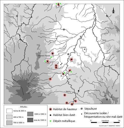 Identified occupations sites
in Lower Auvergne in the Late Bronze 3 age (950-800 BC.)
Identified occupations sites
in Lower Auvergne in the Late Bronze 3 age (950-800 BC.)
1:
Bègues, 2 Gergovie, 3 Corent - doc. arafa.fr
These relatively recent discoveries have to get a new idea about the
Gauls:
These
strategic locations were connected by roads before the Roman conquest ... they allowed the legions to move quickly from one point to another, before the construction of the famous Roman roads,
and trade with Rome before the conquest.
The Gallic salted meals and the Roman wines are exchanged.
 Restoring of the "Gallic" Corent - Doc. 3D luern
In the foreground, the Chamber
assertion - left, the sanctuary - to the right, the market and at the rear of the esplanade, the village.
Excavations between 2001 and 2005
showed the existence of a sanctuary 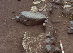 dated from 150 to 50 BC. In
an area bounded by a wooden fence primarily, then with a gallery of wood poles, the sanctuary was equiped with a sacrificial altar in basalt (photo LUERN).
dated from 150 to 50 BC. In
an area bounded by a wooden fence primarily, then with a gallery of wood poles, the sanctuary was equiped with a sacrificial altar in basalt (photo LUERN).
The enclosure ditch provided testimony offerings of this period : human skulls associated with animal bones, weapons,  brooches, glass or bronze beads.
Several convergent
indications attest of the manufacturing of Gallic coins, in bronze and silver, at the very entrance of the sacred precincts.
The sanctuary played a central role in the religious,
political and economic life of Arvernes at the end of the Iron Age.
At the foot of the oppidum, a museum space - "the cellar of Luern" - includes amphorae. It bears the name of King Arverne Luern (Luernos), known in the 2nd century BCE for the festivities
organized for his subjects.
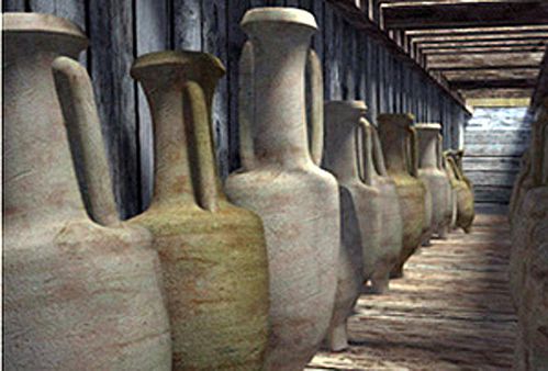 Corent - museum space "cellar of Luern" - Doc. Luern
It
is found metal dishes, clay cups from Delos, or in glass from Syria ... which confirms trade relations between Gaul and the Mediterranean.
Geological history :
The history of the Puy de Corent is divided into two periods: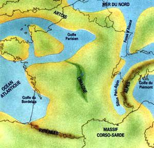 1. a lake occupied
the territory in the Oligocene (34-23 Ma) ... the erosion of crystalline rocks resulting in the deposition of arkoses, then limestone and marl with little gypsum. The area is dewatered at the end of the Oligocene.
1. a lake occupied
the territory in the Oligocene (34-23 Ma) ... the erosion of crystalline rocks resulting in the deposition of arkoses, then limestone and marl with little gypsum. The area is dewatered at the end of the Oligocene.
The schematic situation of Limagne at Oligocene
doc. Ademir Commercy
2. The ascent of basaltic magma is in the basin
of Limagne, in a lacustrine environment at this time.
Violent phreatomagmatic explosions spray the
lava in little particles, while the Oligocene sediments sprayed mingle intimately. The material
formed, the peperite is deposited to form a ring of tuff. Then the magma no longer meets
water: a Strombolian cone shape and basanite flows pours ... the eruption of the Puy de Corent is dated 3 Ma
Finally, the erosion will shape the bottom of the valley and create an inverted terrain. The lava cover, very durable, allows the preservation of
sedimentary sequences or phreatomagmatic devices covered.
 Corent - the current city
and the Corent plateau with a lakeside - Photo JP. Brown / CEN Auvergne
Corent - the current city
and the Corent plateau with a lakeside - Photo JP. Brown / CEN Auvergne
All
sediment outcrops today with a thickness of 170 meters from the banks of the Allier to the base of the casting forming the top of the plateau.
Pépérites of the southwest side have a typical
peppered facies with centimetric fragments of basanite screening a marl-limestone cement.
The uppermost table of Corent is 1500 meters long and 500 meters wide. Its southwestern part is topped by a breached cinder cone dominant the plateau of 80
meters.
In front of the Corent plateau, and in
the same volcanic context, is the plateau of Gergovie discussed above - link
Sources :
- Guide des volcans d'Europe et des Canaries - par M. Krafft et F.de Larouzière - éd. Delachaux et Niestlé
- LUERN - Laboratoire Universitaire d'Enseignement et de Recherche en archéologie Nationale - Fouilles de Corent - link
- Archéologie en Auvergne - L'Auvergne de l'âge du bronze
Thème Magazine - Hébergé par Overblog


/image%2F0935525%2F20221112%2Fob_03b696_ethiopie-scanner-bd-018.jpg)
/image%2F0935525%2F20221111%2Fob_1285d5_site-troglodyte-de-jonas-jmm.jpg)
/image%2F0935525%2F20221108%2Fob_d0f7fc_site-troglodyte-de-jonas-jmm.jpg)
/image%2F0935525%2F20221110%2Fob_af1829_puy-mary-2-jmm-1-28-10-2022.jpg)