
Actualité volcanique, Articles de fond sur étude de volcan, tectonique, récits et photos de voyage
Par Bernard Duyck
Near the Columbia River and Portland, a massive stratovolcano consists of several andesitic to dacitic domes, Mount Hood, is an ever present threat to the well region.
These domes were produced during eruptions in the last 730,000 years, based on an ancient volcano this for millions of years.
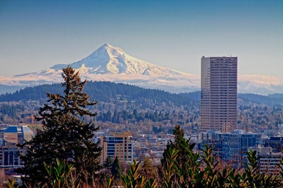
The Mt. Hood dominates the city of Portland - photo Ed Rudlledge / USGS
Mount Hood is covered with glaciers, and has produced during recent eruptions number of lahars, the latest, not associated with an eruptive activity, reached the Columbia River in 2006.
The volcano has experienced periods of activity of tens or hundreds of years, separated by quiescent periods lasted between hundreds of years and 10,000 years.
Pleistocene collapses produced avalanches and lahars which spread along the Columbia River to the north.


On the left, the glaciers of Mt. Hood - doc from Lidar data / USGS - right risk map - Doc USGS - A click to enlarge
The volcano has experienced at least four major eruptive periods since 15,000 years, including three years since 1800:
* Polallie (between 15,000 and 12,000 years) eruptions are contemporaneous or following the Pleistocene glaciation.
* Timberline (between 1,800 and 1,400 years)
* Zigzag (between 600 and 400 years)
During both this 2 periods, debris avalanches and lahars have borrowed the valleys of the Zigzag River and Sandy River toward the Columbia, installing a delta in the Sandy river, and moving over the Columbia River.
* Oldmaid (between 250 and 180 years) pyroclastic flows and lahars, generated by repeated collapses of a lava dome extruded near the current Crater Rock, the remains of the dome, have created deposits distributed between the Sandy River and the White river. Early settlers reported an eruption in 1859 and 1865 to 1866, the official date of the last eruptive activity (in GVP)
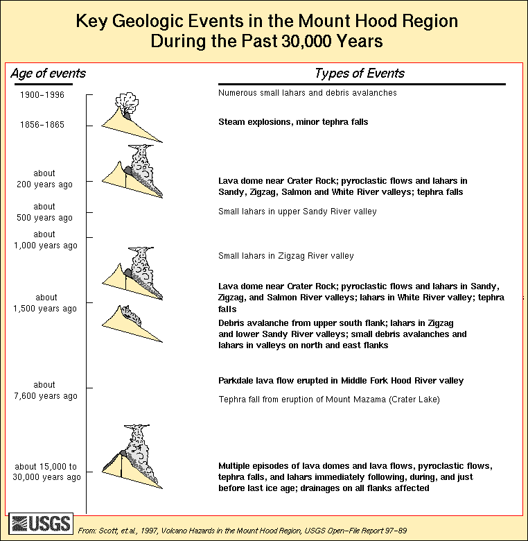
Date and description of geological events in the region of Mt. Hood in the past 30,000 years - Doc. USGS
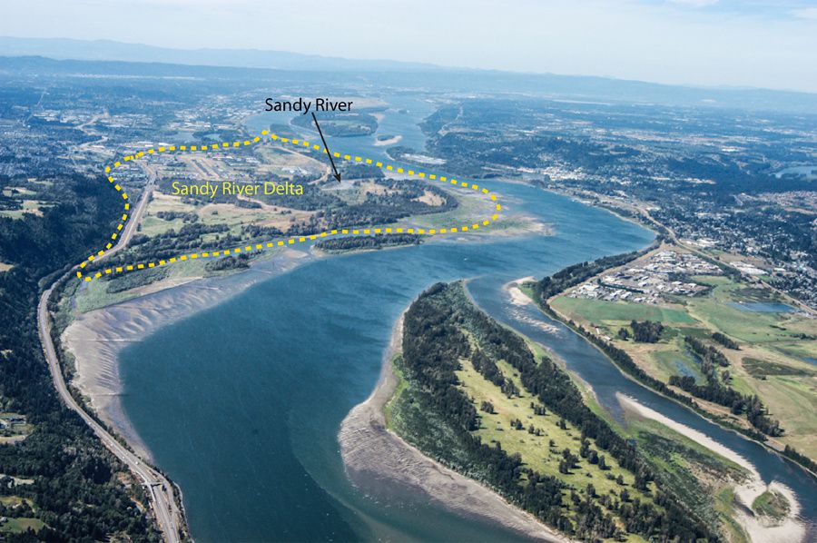
The delta of the Sandy river, dating from the "Timberline" eruptive period of Mt. Hood - photo Willie Scott / USGS

The southern flank of Mt. Hood, with Crater Rock - photo © Jean-Michel Mestdagh
Near the Timberline Lodge, Crater Rock is a remnant of the dacite dome (hypersthene-hornblende) formed there 2-300 years ago. Her measurements: 300-400 m. at its base and top of 170 m. on its south side; it is surrounded by an area of brecchia of the same composition.
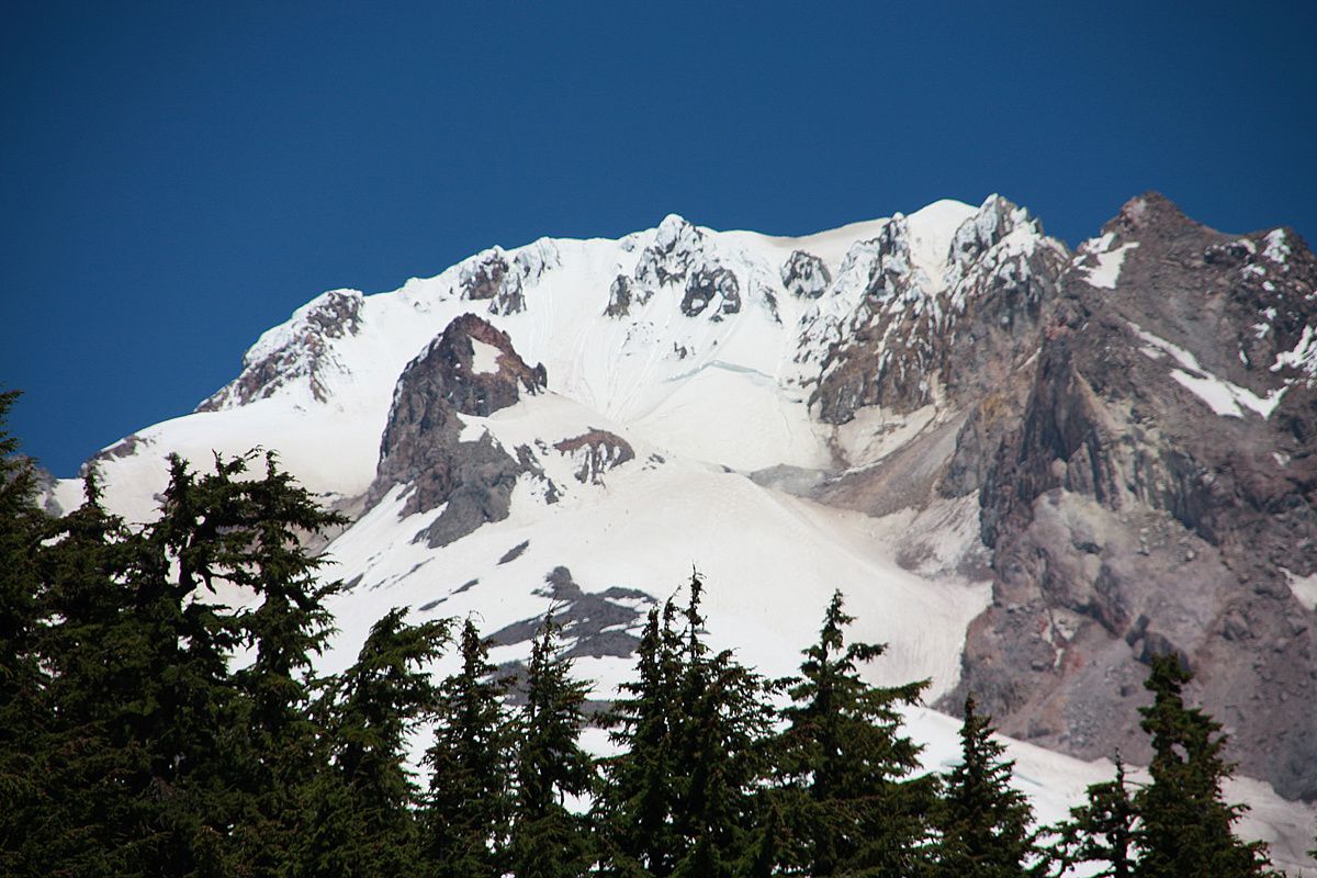
Summit of Mt. Hood, with Crater Rock, less snow covered in the center-left - photo © Jean-Michel Mestdagh

Steaming altered ground of the Mt Hood's summit - James Howles USGS
A strong fumerolian activity persists today in its surroundings.
The maximum temperature of the fumaroles was measured at 92 ° C, slightly above the boiling point of water at this altitude point at the main geothermal area of the volcano is called "Devil's kitchen" ... this s 'not invented!
Sources :
- Global Volcanism Program - Hood
- Cascades Volcano Observatory / CVO - Mt. Hood
- USGS - Mount Hood - History and hazards of Oregon's most recently active volcano - link
Thème Magazine - Hébergé par Overblog


/image%2F0935525%2F20220824%2Fob_233d4b_thrihnukagigur-volcano-guide-to-icelan.jpg)
/image%2F0935525%2F20220111%2Fob_894d24_particolare-dei-colli-euganei-il-mon.jpg)
/image%2F0935525%2F20201012%2Fob_4fcdc5_img-8284-copie.jpg)
/image%2F0935525%2F20200802%2Fob_46d8ae_columbretes-seis1-castellonturismo.jpg)