
Actualité volcanique, Articles de fond sur étude de volcan, tectonique, récits et photos de voyage
Par Bernard Duyck
The Monowai seamount, located in the Pacific Ocean midway between the group of Tonga and Kermadec isles 1500 km northeast of New Zealand, has erupted three times in the second half of the month October 2014, each time for a few days.

Situation of the Monowai seamount north of the Kermadec volcanic arc - NOAA map

Surface debris produced by an eruption of Monowai seamont on October 31, 2014 - doc.RNZAF / GeoNet
A report by the volcanologist Brad Scott, of GeoNet / New Zealand, gives us the means to detect this kind of submarine eruption distant from the land: erupting, a submarine volcano produced an unusual seismic wave, called "T-wave ", that spreads well in the oceans.
T-waves from Monowai were recorded by a seismograph in Rarotonga, 2000 km away to the east in the Cook Islands and in French Polynesia. These observations were confirmed visually by an aircraft flying over the area of Monowai on October 31, when the production of a third wave of T-wave.

Records of three T-wave periods detected in Rarotonga corresponding to the periods of high activity in October 2014 - Doc. GeoNet
More about the Monowai :
This is one of the most active submarine volcanoes in the southwest Pacific.
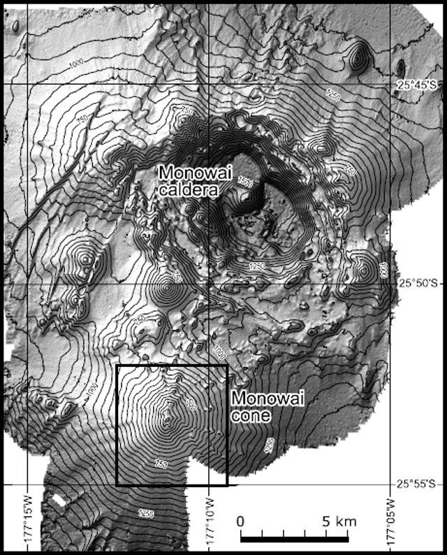
It consists of a large oval caldera 11 km x8.5, 1,500 meters deep, where hydrothermal activity is reported. On its southwestern edge, stands a stratovolcano, 1,000 meters high and a basae width over 10 km. Small parasites cones punctuate its northern and western flanks. The total is estimated at more than 500 km² in surface.
The caldera and cone Monowai - Doc. top: courtesy of Wright and others, 2008 / GVP - do. bottom: courtesy of Ian Wright, 2005 (NIWA; http oceanexplorer.noaa.govexplorations05fire).
The caldera and cone Monowai - Doc. top: courtesy of Wright and others, 2008 / GVP - do. bottom: courtesy of Ian Wright, 2005 (NIWA; http oceanexplorer.noaa.govexplorations05fire).
The depth of the climax of Monowai varied between 1997 and 2007 meters and -128 -49 meters from the bathymetric surveys.
Monowai bathymetries between 2004-2011- Evolution of the morphology and depth of the climax. - Doc.courtesy of Watts and others (2012). GVP in

The caldera and cone Monowai - Doc. top: courtesy of Wright and others, 2008 / GVP - doc. bottom: courtesy of Ian Wright, 2005 (NIWA; http oceanexplorer.noaa.govexplorations05fire).
The depth of the highest point of the Monowai varied between 1997 and 2007 between -128 meters and -49 meters, from the bathymetric surveys.

Monowai bathymetries between 2004-2011- Evolution of the morphology and depth of the highest point - Doc.courtesy of Watts and others (2012). in GVP.
Since its characterization as a volcano in 1977, many eruptions have been detected by underwater acoustic signals. In August 2012, the eruptive activity is recorded by seismographs of Rarotonga. The activity of 2014 seems less important than that recorded in 2009 and 2012.
Discoloration of the surface water, a vigorous gas bubbling or areas of turbulence are also observed.


To the left, the 3D image of Monowai - Doc Chadwick, WW, et al. (2008) via GeoNet -to the right, growth to southern of the Monowai cone from 1978 to 2011 - Doc. Watts and others (2012) in GVP - a click to enlarge.
Despite its remoteness, the seamount is monitored as likely to be in the future the site of phreatomagmatic eruptions, generating such significant ash plumes ... on the layout of roads frequented by aircraft, or to present flank collapses associated with risk of tsunamis.
Sources :
- GeoNet - Remote sensing of submarine eruptions at Monowai volcano - link
- Global Volcanism Program - Monowai
Thème Magazine - Hébergé par Overblog


/image%2F0935525%2F20221031%2Fob_614820_2022-10-30-18h33-wit-gunung-ibu-p.jpg)
/https%3A%2F%2Fi.ytimg.com%2Fvi%2FoOCJ-5qxdO8%2Fhqdefault.jpg)
/image%2F0935525%2F20221029%2Fob_ff7a2c_2022-02-28-22h06-utc-pavlof-sat-wor.png)
/image%2F0935525%2F20221028%2Fob_fb9420_2022-10-26-survol-du-cotopaxi-par-le-f.jpg)